Blue hake Antimora rostrata Günther 1878
[Jordan and Evermann, 1896-1900, p. 2544, as A. viola Goode and Bean.]
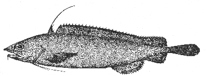
Figure 112.—Blue hake (Antimora rostrata), La Have Bank. From Goode. Drawing by H. L. Todd.
Description—
This species resembles the white, squirrel and spotted hakes in the form of its body and in having two separate dorsal fins, the first very short and the second very long; but it is readily distinguished from them by the fact that its anal fin is so deeply notched about midway of its length that it almost seems to have two separate anals, and that each of its ventral fins is 6-rayed, with the second ray prolonged and filamentous. The shape of the snout, which is flattened above, keeled at the sides, and blunted at the tip in some but forming an acute angle in others is distinctive, likewise its vent is situated much farther back than in the true hakes (genus Urophycis), and its body, in life, is deep violet, blackish brown, or blue black, below as well as above.
Size—
The longest yet measured was one of about 211/2 inches (545 mm.).
Range—
The blue hake was reported at so many localities along the continental slope from the early cruises of the U. S. Bureau of Fisheries[58a] on the Nova Scotian slope; off southern New England; and southward to the offing of Cape Hatteras, North Carolina, at 350 to 1,000 fathoms that it must be one of the more plentiful of fishes there.
We have recently trawled a few at 220 to 460 fathoms, on the southeastern Nova Scotian slope, on the Caryn of the Woods Hole Oceanographic Institution, between longitudes 64° W. and 65° 56' W., and halibut fishermen have occasionally brought them in. But the blue hake has not been taken within the limits of the Gulf of Maine, and it is hardly to be expected there; the shoalest capture recorded for it so far is from 220 fathoms. We mention it on the chance that vessels trawling on the slope may occasionally work deep enough to pick up a few.
The known range of this deep sea hake includes the North Atlantic from Denmark Strait to the offing of Gibralter in the east and from the Newfoundland Banks to the offing of Cape Hatteras in the west; Uruguay; the eastern Pacific, British Columbia to Panama, and the southern Indian Ocean. It has been taken as deep as 1,456 fathoms.[59]