

Existing data on environmental quality in Merrymeeting Bay are reviewed. Data and information were collected from peer&endash;reviewed and other literature and by means of interviews with researchers and interested citizens. Relatively few data were available given the ecological significance of the Merrymeeting Bay ecosystem. The ecosystem is described in general terms. The available environmental data are reviewed in the context of the ecosystem. Significant flushing, due to large riverine flows, appears to have protected Merrymeeting Bay from eutrophication. Effects of toxic contaminants are less clear. Research needs and recommendations for management actions are included.
The primary purpose of this report is to evaluate and summarize the existing data on environmental quality in Merrymeeting Bay. The report will allow the Friends of Merrymeeting Bay (FOMB) to further its mission of preserving, protecting and improving the unique ecosystems of the Bay. FOMB will use the report to identify what should and can be done to protect and improve the health of the Bay. The report identifies gaps in our knowledge of the Bay as well as recommendations for filling these gaps.
Ecosystem Type
Formed by the confluence of two major rivers and four smaller tributaries, Merrymeeting Bay is an inland, freshwater river delta, encompassing 9,600 acres of wetland habitat. Seventeen miles upstream from the mouth of the Kennebec River, the Bay is subject to the tidal forces of the Gulf of Maine: it exhibits a six foot tidal range. Merrymeeting Bay is one of the largest and most important freshwater tidal ecosystems in the country.(Gulf of Maine Coastal & Estuary Project: 1994)
Little quantitative data exist that describe the structure and function of the Merrymeeting Bay ecosystem. Home to endangered species, critical to tens of thousands of migrating and resident waterfowl, habitat for recovering populations of anadromous fish, and a rare ecosystem, it is stunning that so little information on this remarkable water body exists. This may be because 1) as an unusual form of aquatic ecosystem, Merrymeeting Bay is not often studied by researchers familiar with more common forms, and 2) tides and currents make it difficult to get a research vessel into the Bay to collect samples and data.
An ecosystem is defined as an interacting system of living organisms with their physical environment. The bounds of an ecosystem are arbitrary as all ecosystems are part of larger systems, ultimately encompassing the entire planet. Only by understanding how the various components of the Merrymeeting Bay ecosystem interact can we identify indicators of ecosystem health and determine appropriate strategies for protection. We all recognize that Merrymeeting Bay is a special place but few understand what a rare form of ecosystem it is. Called "tidal riverine" and "an inland delta", the Bay is neither river, lake nor estuary, but a hybrid of ecosystem types that is quite unusual.
Merrymeeting Bay is not a bay, despite its appearances. At the convergence of two great rivers, it is much more like a freshwater river than a bay, but with two significant differences: 1) it is partially impounded by the constriction known as the Chops and 2) it is subject to the action of the tides. Unlike most rivers, the Bay has vast, vegetated intertidal flats which support a very productive and diverse biological community. Because the Bay is shallow, the relatively large volume of water flowing through the Bay combines with the effect of the tides to limit the stratification of the water column that characterizes most bays (as well as lakes). Finally, although subject to the action of the tides (undoubtedly the source of its identification as a "bay"), the Bay is essentially freshwater in nature with little of the biological community associated with marine and estuarine ecosystems.
Geology
The geology of the Bay, its primary physical aspect and therefore the place to start in describing the Bay ecosystem, explains its unusual status. The Bay was most likely originally formed by an ancestor of the Kennebec River. However, its early history has been obliterated by the events of the Ice Age and by sea level change. The ice depressed the land; when the ice retreated, the ocean flooded the land as far inland as Bingham. Ocean sediments were deposited, covering the ancient land forms. As the land began to rebound, the Kennebec reclaimed its channel, eroding the deposited sediments and carrying them downstream to the mouth of the river. A large delta resulted and began to block the mouth of the river which at that time most likely emptied into Maquoit Bay. A similar phenomenon was occurring in the Androscoggin. It is hypothesized that a cataclysmic flood was the final factor in creating Merrymeeting Bay: the flood waters were blocked, at least in part, by the delta and were forced instead to move through the Chops and enter the sea at Popham. (Kelley,J.T. & A.R. Kelley:1989)
Post Ice Age, sea level has continued to rise. Several of our coastal estuaries, such as the New Meadows and Damariscotta Rivers, are drowned river valleys with little freshwater inflow. Their ecosystems are dominated by the marine environment. Rising sea level has also affected the Kennebec River and contributes greatly to the unusual character of Merrymeeting Bay. Although high volumes of freshwater flow from the Androscoggin and Kennebec Rivers (combined they account for 98% of the flow into the Bay), the force of the tides is also felt strongly in the Bay. Tidal range is as great as 6 feet in the Bay proper, and 4 feet at the Topsham&endash;Brunswick Dam; head of tide on the Kennebec is thirty miles upstream at the Edwards Dam in Augusta. Although salinity in the Bay is insignificant, the action of the tides on the Bay?s huge deposits of sand is a dominant force in the Bay ecosystem: it allows for the development of vast and productive stands of aquatic vegetation.
Hydrology
The hydrology of the Bay can be visualized as follows: freshwater flowing from the Kennebec and Androscoggin Rivers converges in the Bay with the majority of the flow coming from the Kennebec. The tremendous, combined flow of these rivers is very large in relation to the volume of the Bay. As a result, the Bay is subject to greater current energy than comparably sized water bodies. A very small amount of flow comes from the remaining tributaries of the Bay of which the Abagadasset, Cathance, Muddy and Eastern Rivers are the most significant. The volume of freshwater inflow is very seasonal; spring rains combined with snow melt result in a substantial increase in flow from March through May. Spring flows can account for up to 50% of the total yearly flow. (Learded, R. 1995) The convergence of the two major rivers most likely results in considerable mixing during the ebb and flood of the tide; however, little has been documented about the action of the currents within the Bay. The major direction of flow is evident from the channels scoured by the rivers in the middle of the Bay. Unknown is the size, direction, stability and effects of eddies that most likely occur in the backwaters and intertidal areas of the Bay. While the smaller tributaries do not contribute much in the way of flow, they may act as traps for eddies and sediments.
Tidal Influence
The action of the tides is superimposed on this annual pattern of freshwater flow in and out of the Bay. When freshwater meets salt water in an estuary, the less dense freshwater tends to ride over the salt water, creating a salt wedge. The wedge moves up the river with the incoming tide and recedes with the ebb. In the lower Kennebec estuary, mixing of fresh and salt water reduces stratification and ?blunts? the wedge. Salinity values from the Bay indicate that at times of low flow the leading edge of the wedge makes it into Merrymeeting Bay as far north as Swan Island but that generally the wedge remains in the lower Kennebec. (Mayer, L.M., D.W. Townsend, et al 1996) This indicates that the tides in the Bay are to some degree a result of freshwater being "backed up" in the Bay rather than due to the intrusion of salt water itself into the Bay. Tidal force varies from day to day and month to month with the highest tides occurring monthly and at the time of the spring and fall equinox. By comparing tidal height and freshwater flow it is possible to predict that maximum salt water intrusion into the Bay will occur in the fall when river flows are lowest, particularly when tides are highest. Conversely, the salt wedge is most likely furthest south in the estuary in the spring when the freshet occurs, particularly when tides are lowest. At such times, the salinity of the Kennebec is noticeably depressed as far south as its mouth. (Mayer, L.M., D.W. Townsend, et al 1996)
At highest river flows, residence time, or the length of time water remains in the Bay, can be measured in hours, shorter than in tidally mixed estuaries and much shorter than in lakes. (Mayer, L.M., D.W. Townsend, et al 1996) At low flows, residence time may be on the order of a few weeks. Furthermore, as the Bay is not uniformly mixed, residence time may vary considerably from the Bay proper to the heads of its smaller tributaries.
The unusual nature of the Bay is thus a function of physical forces: two vast watersheds (9,320 square miles, more than one third of the state of Maine) release a large flow of freshwater and attendant sediments into the Bay; geology constrains the movement of water and sediment from the Bay to the lower Kennebec estuary, and significant tidal forces further affect sediment and water movement.
Sediment Dynamics
Although the Kennebec contributes the most water to Merrymeeting Bay, the Androscoggin accounts for the majority of sediment that flows into the Bay (the minerals from the two rivers are different and can be distinguished in the sediments of the Bay). (Joe Kelley, State of Maine Marine Geologist, personal communication) The combination of sedimentation and the action of the tides has created extensive intertidal flats, covering almost one half of the Bay.
The movement of sediments in Merrymeeting Bay is not well understood. Geologists now think that the lower Kennebec contributes sediment to an enormous, offshore delta only during the spring freshet; during the remainder of the year, tides actually move sediment back up the river, at least as far as Bath. Therefore, it is likely that sediment flows out of Merrymeeting Bay only during the time of high flows. Satellite imagery clearly showed a plume of sediment exiting the Kennebec estuary during the 100&endash;year flood that occurred in 1987. Episodic outflow of sediment has no apparent effect on the flats of the Bay because eroded sand is readily replaced by new material transported downstream by the Kennebec and Androscoggin. (Joe Kelley, State of Maine Marine Geologist, personal communication) In many bodies of water, sedimentation results in transition through successional stages: lakes become ponds, ponds become marshes and marshes become upland. While the river flows coursing through the Bay will undoubtedly keep it free flowing, accumulation of sediment in the Bay could alter the character of its vast wetlands. The ongoing rise in sea level may also offset the effects of sedimentation in the Bay. As sea level rises, the level of the Bay rises and shoreline continues to drown as it has throughout the mid&endash;coast area. It is unclear, however, if Merrymeeting Bay is in transition geologically or remains in dynamic equilibrium.
Primary Production
The biology of the Bay is dominated by the physical processes described above, most likely to a greater degree than occurs in lakes and estuaries. In many water bodies, phytoplankton (free&endash;swimming, single&endash;celled algae) are the most significant contributors to the growth of plant material known as primary productivity. Algal cell counts in Merrymeeting Bay are lower than at the mouth of the Kennebec estuary except during times of low flow. (Mayer, L.M., D.W. Townsend, et al 1996) The substantial flow of water through Merrymeeting Bay most likely flushes phytoplankton from the system before significant growth takes place thereby preventing this planktonic form of plant life from contributing substantially to primary productivity in the Bay. On the other hand, the deposition of sand from the rivers, in the form of immense intertidal flats, provides habitat for rooted, vascular plants which have no such limitations. Vegetated flats cover as much as one third of the Bay and are the dominant feature of the Merrymeeting Bay ecosystem.
The rooted vegetation also benefits from the action of the tides in oxygenating the sediment. In all water bodies, dead plant and animal matter accumulates in the sediment where the action of decomposing bacteria reduces this organic material to nutrients essential to plant life. The exceptionally high energy of the flows through Merrymeeting Bay reduces the deposition of organic material; however, the plants themselves act as a trap for small particles and lead to the accumulation of finer, organic&endash;rich sediments. Decomposition of organic matter in sediments is considerably slowed when bacteria deplete the supply of oxygen, a common condition in continuously inundated sediments (and organically enriched water). Tides enhance decomposition of organic matter by bringing the oxygen&endash;rich surface layer in contact with the bottom.
Limits to the Biological Community
The strong currents of the Bay, driven both by tides and river flow, affect its animals as well as its plants. In many areas such as subtidal or lower intertidal marine ecosystems, biological processes such as predation and competition are the determining factors in community composition.(Raffaelli D. and S. Hawkins. Intertidal Ecology . 1996) In other areas, such as upper intertidal estuarine ecosystems and Merrymeeting Bay, physical tolerance of the resident species is determinant of community structure. Currents prevent deposition of fine&endash;grained, organic&endash;rich sediments in much of the Bay and constantly rework the extensive deposits of sand. The dynamic nature of these sediments prevents many types of invertebrates from settling. Inhabitants must be mobile so that they can adjust to the movement of the sand. Not only does sand movement limit settlement of animals but the lack of organic matter, swept away by the currents, limits the availability of food. In subtidal parts of the Bay, the currents are too strong for many pelagic or free swimming species. In the intertidal areas, exposure limits colonization by many species. Cold temperatures may drive some species from the Bay in winter.
Food Web
Living plant material is the basis of the food chain. In one branch of the food chain living plants in Merrymeeting Bay are consumed by waterfowl, insects, and possibly some fish. Detritus (organic matter from decaying plants and animals, aquatic and terrestrial) produced in the Bay or imported by the rivers, forms the second branch of the food chain. Bacteria consume dead organic material resulting in its decomposition. Particles of decaying material are consumed by small invertebrates, such as insects, mollusks and crustaceans who most likely gain most of the nutritional benefit of such meals from the coating of bacteria on the particles rather than from the remnant of the plant or animal matter itself.
Little information exists on the trophic structure, or food web, of Merrymeeting Bay. A study of the potential impacts of construction of the Brunswick&endash;Topsham by&endash;pass identified the type and quantity of benthic macrofauna at three stations in the western part of the Bay: upstream of the by&endash;pass site, the by&endash;pass site, and downstream (north&endash;east) of Mustard Island.(Marine Department of Transportation. 1994) The density of organisms ranged from 258 to 5,339 organisms/m2 . The communities studied were typical of those normally found in sandy, riverine environments. The most common organisms found were oligochaete worms, small freshwater bivalves, and chironomid insects. These invertebrates are preyed upon by amphibians, reptiles, small mammals, birds and fish. Sturgeon feed on benthic invertebrates by rooting in the sediment.
Amphibians, reptiles, and small fish are consumed in turn by animals at the top of the food chain, including fish, such as striped bass, and birds, such as herons, ospreys and eagles. A 1980 study noted a winter food relationship among eels, common mergansers and bald eagles. Fefer, S.I. , L.L. Thornton,et al. 1978) Eagles living near freshwater consume primarily fish; those in the coastal zone feed largely on birds, mostly black ducks and gulls.
Several exotic species now occur in Merrymeeting Bay including brown trout, carp and white catfish. The effect of such populations on the Merrymeeting Bay ecosystem is unknown.
Net Productivity
The net growth of plants and animals in an ecosystem is known as its productivity. The productivity of Merrymeeting Bay is enhanced by the input of organic matter from its tributaries and terrestrial plant matter that falls into the Bay. The Bay's productivity is exported in several ways. Dissolved or particulate organic matter is drained from the Bay with each ebb tide. Migrating waterfowl fatten up on wild rice and other food before departing for their wintering or breeding grounds. Mature anadromous fish, such as alewives and shad, live at sea and spawn in Merrymeeting Bay and its tributaries; juveniles utilize the Bay for several months before departing for marine waters. Catadromous eels grow to maturity in the Bay and then leave to spawn and die in the Sargasso Sea. Although there are no data on the net productivity of the Bay, it is likely that Merrymeeting Bay is a net exporter of productivity, supporting ecosystems to which it is connected. In this and other ways, Merrymeeting Bay is integrally connected with other ecosystems.
Limits to Data
While little information exists describing the Merrymeeting Bay ecosystem, even fewer quantitative data are available on the environmental quality of the Bay. As mentioned above, this may be due in part to the fact that Merrymeeting Bay has largely failed to draw the attention of researchers and is difficult to sample from traditional research vessels. But also, and importantly, state regulatory agencies consider the Bay as a receiving water for two large rivers, not as an ecosystem in and of itself. The results of several studies are described below.
Nutrients and Phytoplankton
In 1993, Larry Mayer, along with other researchers from the University of Maine and elsewhere, began a collaborative, long&endash;term study of the hydrography, nutrient regimes, planktonic populations and suspended particulates of the Kennebec, Sheepscot and Damariscotta River estuaries. (Mayer, L.M., D.W. Townsend, et al 1996) Their studies included a handful of stations in Merrymeeting Bay. In reviewing the historical data for each estuary, they found that "almost no data existed for the Kennebec estuary" including Merrymeeting Bay. In 1983, the Maine Department of Environmental Protection (MDEP) collected data throughout the summer on dissolved oxygen concentration and fecal contamination in Merrymeeting Bay. Similar data were collected at the same stations once during 1989. However, and unfortunately, Mayer, et al., chose not to monitor these parameters as part of their research.
According to Mayer, et al., the Kennebec exhibits a surprisingly strong "internal" nutrient source which appears to be derived from "organic material delivered to the estuary from up river." What is unclear is how much of this organic material is produced in Merrymeeting Bay and how much is imported to the Bay and the lower Kennebec, from the Androscoggin and upper Kennebec. Mayer, et al., also hypothesize that the source of suspended particulates in the Damariscotta and Sheepscot may be resuspension of sediments, but that the level of such particulates in the Kennebec may be due to "human sources." It is also unclear how the results of this study relate to the history of organic enrichment in Merrymeeting Bay. Clearly, the Bay is subject to much less organic pollution than it was thirty years ago. Construction of sewage treatment plants, restriction of industrial dumping and elimination of log drives have greatly reduced the amount of organic matter reaching the Bay. Even at its worst, Merrymeeting Bay probably fared better than other water bodies subject to organic enrichment. Rapid flushing of the Bay most likely removed a large percentage of material imported to the Bay. Tidal currents contributed to the rapid decomposition of remaining organic matter through aeration of sediments and the water column. Anecdotal evidence indicates that the wild rice in Merrymeeting Bay has declined over the last several years. It is possible, although undocumented, that wild rice and other aquatic plants may have benefited from the surplus nutrients while tidal flushing limited the build up of planktonic algae that is characteristic of water bodies subject to organic pollution.
Toxic Contaminants
Toxic contaminants, such as trace metals and chlorinated organic compounds, that are introduced into bodies of water, rarely dissolve. Instead, they adsorb (or adhere) to particles of organic matter and sediment that are suspended in the water. When such particles settle to the bottom, the contaminants are removed from the water column and become part of the sediment. Mud has a much greater surface area than a comparable volume of sand; as a result, sources of contamination being equal, mud will have a greater load of contaminants than sand. Sediments with greater amounts of organic matter will also have more contaminants. In other words, muddy, organic-rich sediments become sinks for contaminants released into the water column.
In Sediments
In judging the toxicity of a sediment sample, the absolute concentration of contaminants must be considered. However, in looking for patterns in contaminant distribution, contaminant concentration must be considered in relation to the grain size and organic content of the sediment. Contaminant concentrations frequently reflect the distribution of muddy, organic&endash;rich sediments rather than sources of contaminants.
The distribution of toxic contaminants in Merrymeeting Bay most likely reflects the distribution of muddy sediments. The location of these sediments is known only in a general sense; they occur in the backwaters and eddies of the Bay where currents are slowest and where aquatic vegetation is concentrated. Unfortunately, these areas are not very accessible by boat, the standard means of collecting sediment samples for analysis of toxic contamination.
In 1994, Chilcote and Waterfield, in collaboration with MDEP, conducted a study of toxic contaminants in Merrymeeting Bay, from Cow Island in the Androscoggin to the Richmond Bridge.(Chilcote, M.A. and M.R. Waterfield. 1995) A boat was used to deploy a sediment sampler. Although efforts were made to locate stations "in calm areas where contaminant&endash;rich fine sediments would accumulate," sediments collected were primarily sandy. Vegetated areas were avoided, presumably because the vegetation would impede the action of the sampler. The authors found a strong correlation between grain size and organic content. They noted that the Androscoggin stations (Cow Island to Mustard Island) were much sandier than the Kennebec stations (Abagadasset Point to the Richmond Bridge). The authors identified "pollutant signatures" associated with the regions of the Bay: the Androscoggin stations had the highest levels of polycyclic aromatic hydrocarbons (PAHs) and mercury and the Kennebec stations had the highest levels of chromium, arsenic and selenium, even taking grain size and organic content into account. The Bay proper exhibits more moderate contaminant levels than those found in the two rivers.
Chilcote and Waterfield compared levels of sediment contaminants with levels known to cause toxic effects as identified in an Environmental Protection Agency (EPA) study. The authors noted that with the exception of arsenic, metals were well below effects thresholds. Arsenic exceeded low effects levels at over half the stations sampled; highest levels were reported for the Kennebec stations and the Androscoggin stations were below the effects threshold. Three of the PAHs analyzed exceeded the low effects threshold at one of the Androscoggin stations. On the basis of low levels of contamination relative to effects thresholds for most of the stations in the study, the authors conclude that Merrymeeting Bay "appears to be in good health."
Such a finding must be qualified for two reasons: 1) effects thresholds may be a gross measure of toxicity and 2) the study sampled only sandy sediments. Toxic effects levels reported in the literature most commonly represent direct effects on animals that can be measured over a relatively short time period. Such effects range from mortality to impaired immune function. Much harder to measure are long term effects such as reduced recruitment and food chain transfers. Recent studies even indicate that some contaminants' effects are not expressed except in the progeny of the affected animal. The effect of toxic contaminants on aquatic plants is not known. The level of contamination in the Bay and its effect on resident flora and fauna can only be assessed after further study of the distribution of contaminants in Bay sediments and their possible migration up the food chain.
In 1991, Larsen and Gaudette analyzed metals from coastal sediments from Casco Bay to Boothbay Harbor including one station in Merrymeeting Bay and several in the lower Kennebec estuary. (Larsen, P.F. and H.E. Gaudette. 1995) Their goal was to collect samples on a sufficiently broad geographic scale to identify regional patterns in trace metal deposition and "gain insight into possible sources and transport mechanisms." They found that:
"elevated levels of metals...are consistent with the suggestion that principal source(s) of metals to the mid&endash;coast region lie in the large Kennebec&endash;Androscoggin watershed. Metal&endash;binding sediment particles are transported through the dynamic Kennebec estuary to the Gulf of Maine and are dispersed by the currents and tides...until they are deposited in quiescent areas. The distribution of metals in the Sheepscot estuary, that is, reduced levels toward the head of the estuary, adds further support for the Kennebec watershed as a probable source."
One station, just north of Thorne Head in the area below the Chops, exhibited some of the highest sediment metal levels detected in the study. Another station in the Bay, located off Abagadasset Point, exhibited metal levels very near the mean for all stations sampled. The discrepancy is not due to grain size or organic content effects; the Thorne Head station exhibited significantly coarser sediments and lower organic content. Although two stations do not necessarily reflect a trend, it might not be surprising if sediments below the Chops demonstrated higher levels of contamination than those in the Bay, even if the Bay and its tributaries are the source of such contamination. Currents carrying particles of mud (and attached metals) begin to slow as they exit the Chops and the particles begin to settle. Furthermore, the chemistry of salt water speeds up deposition. In freshwater, particles of mud have a net negative charge and repel each other. When the free positive ions of sea water are encountered, van der waals forces cause the particles to bind together and sink. The particles encounter the salt water wedge traveling up the estuary and are usually deposited at the upriver limit of the wedge. In estuaries, this phenomenon results in the creation of large salt marshes and mud flats. Although salt water can occasionally be detected in Merrymeeting Bay as far north as Swan Island, salinity may not be high enough to effect significant deposition. Particles swept from the Bay encounter higher salinities and calmer waters as soon as they exit the Chops; the river in the area of Thorne Head is most likely depositional. The Chops being an effective barrier to the upriver migration of the salt wedge and associated, contaminated particles, it is not surprising to find higher levels of contamination below the Chops than above.
Larsen and Gaudette compared data collected from several stations in Casco Bay in 1991 to similar data collected from the same stations since 1980. They found that levels of several metals appear to have declined, which is consistent with a national study of metal accumulation in mollusks. Copper alone showed an increase, also consistent with national trends. Without a previously conducted baseline survey against which to measure change, it possible only to infer that such trends may also have occurred in Merrymeeting Bay.
In Eagles
In the same study described above, Chilcote and Waterfield analyzed sediments for chlorinated organic compounds including pesticides, DDT and PCBs. None were detected at any of the fourteen stations sampled in Merrymeeting Bay. Evidence of contamination in eagle eggs and nestling blood collected from nests in Bowdoinham and on Swan Island in 1991 and 1992 contrasts with these sediment findings. Compared to eggs from five other nests in Maine, an egg from Bowdoinham had the highest PCB level (66.07 ppm). DDE, a breakdown product of DDT, was also highest in the Bowdoinham egg (0.026 ppm). Mercury (0.653 ppm), the only metal analyzed, was above the mean for the six nests and dieldrin (0.039 ppm), trans&endash;nonachlor (0.345 ppm), HCB (0.031 ppm), heptachlor epoxide (0.030 ppm) and oxy&endash;chlordane (0.021 ppm) were near the mean or lower. Dioxin equivalent analysis (whereby complex mixtures of dioxin&endash;related compounds can be compared) indicated a level of 2,137 ppt total dioxin equivalents in the egg from Bowdoinham, not only an order of magnitude greater than levels in eggs from the other five nests but the highest concentration of dioxin ever measured in any biological sample. The U.S. Fish and Wildlife Service (USFWS) considers the No Observable Adverse Effect Level to be 1.0 ppt. (Linda Welch, personal communication) The dioxin data are reminiscent of data collected in 1974 by USFWS on DDT levels in eagle eggs; an egg from Merrymeeting Bay had the "highest concentrations of DDT yet encountered in eagles' eggs throughout the United States." (Reed and D'Andrea. 1975) Perhaps the same mechanism of bioaccumulation accounts for record levels of one contaminant in 1974 and of another in 1991.
PCBs in the blood of eagle nestlings collected in 1992 from the Bowdoinham nesting site were not as high as those in the blood of a nestling from the Swan Island site. The Swan Island nestling had the highest PCB blood levels in nestlings collected from nine nests in Maine in 1991 and the second highest in 1992 (the Bowdoinham nestling had the lowest). (Linda Welch, personal communication)
While the eagles in Merrymeeting Bay are clearly at great risk from mercury and several organochlorine compounds, it is not clear that Merrymeeting Bay is the source of the risk. It is unknown whether the eagles of Merrymeeting Bay are primarily fish or bird eaters. It is possible that the eagles are consuming prey from outside the Bay or prey from the Bay, such as birds, which, in turn, derive their food from sources outside Merrymeeting Bay.
In Waterfowl
A 1982 study by Longcore, et al., revealed that the extensive use of lead shot in waterfowl hunting had resulted in a relatively high density of shot in Bay sediments, even compared to other hunting areas. (Longcore, J.R. , P.O. Corr, and H.E. Spencer, Jr. 1982) Sediments examined were from marshy areas at the mouths of the Bay's six largest tributaries. The authors estimated that consumption of lead shot resulted in the lethal poisoning of nearly 3% of the Bay's black duck population. Chronic effects were not estimated. Steel shot is now required for waterfowl hunting in Merrymeeting Bay; however, the potential, continuing effect of historical deposits of lead shot on waterfowl and other biota is unknown. Anecdotal evidence indicates that waterfowl populations have declined. In addition to lead poisoning, factors affecting waterfowl populations include habitat loss and other human disturbance, both in the Bay and other areas frequented by waterfowl throughout the year.
Biotic Community
MDEP has sampled the sediment&endash;dwelling macroinvertebrate community downstream of Cow Island. Species found included hydra, flatworms, leeches, water fleas, water mites, aquatic sow bugs, springtails, mayflies, damsel flies, biting midges and black flies. (Maine Department of Transportation. 1990) The species composition indicated a community subject to stress. The type of stress is unclear. The area sampled may be in the dilution zone surrounding the Brunswick sewage plant discharge in which case organic enrichment may be the source of community stress. Chlorine used to disinfect treated waste water may also affect the biota. Anadromous fish are known to be sensitive to extremely small concentration of chlorine. The effect of chlorine on Merrymeeting Bay has not been assessed.
Summary
In summary, environmental data from Merrymeeting Bay are inconclusive in determining the health of the Bay. The status of anadromous fish and waterfowl populations is of concern; however, these species spend part of their life cycle or part of each year outside of Merrymeeting Bay where they may be subject to environmental stresses not found in the Bay. Eagles and ospreys have made a dramatic recovery in Merrymeeting Bay and, yet, we know that at least the eagles are still heavily contaminated. Research on nutrient levels indicates that the Bay is moderately enriched. Rapid flushing of the Bay may minimize the ill effects from such enrichment. There is insufficient data to adequately characterize sediment or biotic contamination in the Bay.
Recommendations for action to enhance and conserve the ecological values of Merrymeeting Bay anticipate a three stage process: characterization of the structure and function of the Bay ecosystem, assessment of anthropogenic impacts and threats, and effective management.
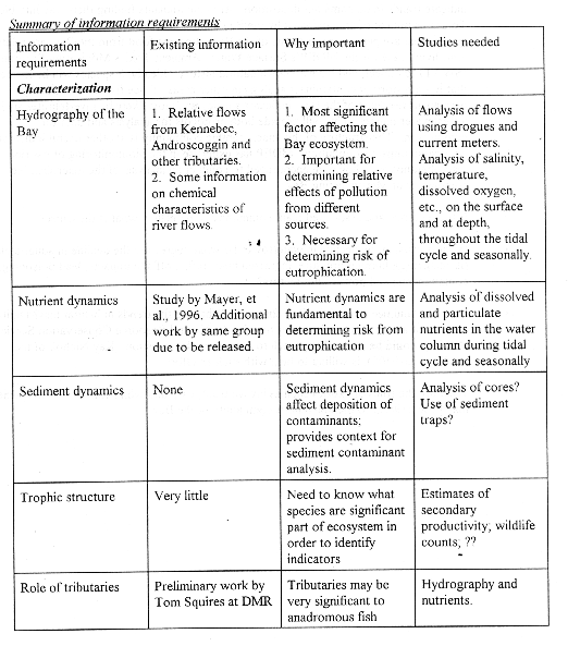
CHARACTERIZATION
Characterization of the Bay should address, at a minimum, the following:
ASSESSMENT
Assessment of the impacts of human activity on the Bay should address, at a minimum, the following questions:

EFFECTIVE MANAGEMENT
Land Use
In 1975, Reed and D'Andrea anticipated that the soon&endash;to&endash;be&endash;completed interstate highway, passing north and south near Merrymeeting Bay's western shore, would result in a significant increase in development along the shores of the Bay; they recommended the use of municipal and regional planning as control on unfettered development. (Reed and D'Andrea. 1975) Passage of state&endash;wide comprehensive planning legislation in the mid&endash;1980s reinforced Reed and D'Andrea's call for effective planning and land use regulation. A planning conference held in 1990 at Bowdoin College renewed the challenge to municipal officials to protect the Bay from unrestrained development.
The need for effective land use management in the watershed of the Bay remains of great importance.
Water Quality
Regulatory agencies do not currently consider Merrymeeting Bay as an ecosystem but rather as a receiving water for two of the state's largest rivers. Early regulation of water pollution in Maine focused on gross pollution of the state's rivers. MDEP's approach was to model the dilution of soluble pollution discharged from point sources and calculate waste load allocations, the amount of pollution that the dilution models predict can be absorbed by a water body without exceeding water quality standards. As a result of these efforts, a decades&endash;old decline in river water quality has been reversed.
With the most obvious sources of pollution under regulation, if not eliminated, attention is turning toward non&endash;point source pollution, or run off. Gradually, the concept of watershed planning is emerging as an ecosystem&endash;oriented approach to protecting surface waters. Implementation of ecosystem management has been impeded, however, by lack of consensus on how ecosystem management can best be accomplished. As a result, pollution in Merrymeeting Bay continues to be addressed as a function of pollution loading in its main tributaries. Loading in the Bay is predicted by models but has not been field&endash;tested. The modeling approach also has a major short coming in protecting the health of the Bay in that it does not account effectively for accumulation of toxic contaminants. The SWAT program is designed to identify where toxic loading is occurring in the state?s surface waters and, ideally, its results are used in conjunction with modeling to regulate toxic discharges. Unfortunately, the SWAT program is limited in scope and can address only a limited number of sites each year.
As a first step toward ecosystem management, Merrymeeting Bay should be reconsidered as a water body with distinctive characteristics and not just as the end point of river modeling.
Habitat
Habitat protection and enhancement can be addressed in several ways. USFWS has identified habitat in Merrymeeting Bay of high value. Protection of these areas through fee simple purchase or other means should be pursued. Where possible, degraded wetlands should be restored by removing pilings and other structures, regrading and planting. Other opportunities for restoration include revitalization of the smaller tributaries in the Bay by removing dams and debris, regrading roads, and re&endash;engineering culverts. (Maine Department of Transportation. 1990) Closure of Maine Yankee may provide the opportunity to remove power lines crossing the Bay that are a hazard to waterfowl.
Monitoring
Monitoring is a management tool because it provides feedback on the effectiveness of management. Monitoring activities should be designed to address each management action. For example, if efforts are made to reduce toxic discharges to the Bay, monitoring of depositional sites in the Bay must include baseline samples against which to measure change. The characterization will be a guide in identifying appropriate indicators of water quality to be incorporated in a monitoring program. Some of the standard indices of water quality may not be appropriate or useful in Merrymeeting Bay. For example, turbidity in the Bay is most likely a function of currents and sediment load rather than eutrophication. Dissolved oxygen may be too variable to be easily monitored.
CONCLUSION
Implementation of the recommendations included in this report will require making the case for Merrymeeting Bay as an ecosystem. Making the case to municipal, state and federal agencies responsible for regulating threats to the Bay, to researchers with the expertise to study the workings of the Bay, to grant programs and foundations interested in funding the work required to protect and restore Merrymeeting Bay. The first step will be building a broad constituency for the Bay. Environmentalists, recreational boaters, fishermen, sportsmen, those interested in protecting open space, and others must come together to form a collective voice for Merrymeeting Bay. Broadening the constituency for the Bay will increase the pressure for action.
It is not likely that any one State or Federal program will provide sufficient funding or overview to carry out the recommendations outlined above. However, it is not necessary that characterization, assessment and effective management, as identified, be completed as part of a comprehensive program or even in step&endash;wise progression. In fact, it is highly unlikely that such a process could be achieved. Characterization, it could be argued, could never be completely achieved given the complexity of the Merrymeeting Bay ecosystem and the limits of environmental science. An iterative approach is more feasible, starting with smaller efforts toward characterization, assessment and management. Funding for such efforts may be available from several sources. As mentioned above, SWAT addresses concerns regarding accumulation of toxics in Maine?s aquatic ecosystems. Priorities for SWAT are set each year; a case could be made for including Merrymeeting Bay among the study sites chosen. The Outdoor Heritage Fund, funded through sales of special lottery tickets, is a relatively new source of funding for projects designed to enhance Maine?s wildlife habitat. State agencies and non&endash;profits are eligible to receive funding. Federal funding is also available for the type of characterization, assessment and enhancement efforts envisioned for Merrymeeting Bay. EPA and USFWS, among others, have ongoing grant programs that may be appropriate sources of funding for Merrymeeting Bay. The American Heritage Rivers initiative, a new Federal program, may be a good target if a basin&endash;wide approach to protecting Merrymeeting Bay is taken. Progress achieved in this manner, funding one aspect of protection at a time, may help to build the case for a comprehensive effort undertaken by a collaboration of agencies and groups and focused on the long&endash;term protection of the Bay. While various funding programs will affect the work that gets done on the Bay, the collective vision for Merrymeeting Bay, propounded by its constituency, will be the driving force in getting that work done.
Chilcote, M.A. and M.R. Waterfield, 1995. "Merrymeeting Bay: An Assessment of Pollution Levels and Sources." Bowdoin College, Brunswick, Maine.
Fefer, S.I., L.L. Thornton, P. Schettig, and R. Brami. 1978. "An Ecological Characterization of Maine's Coast North and East of Cape Elizabeth." U.S. Fish and Wildlife Service, Boston, MA.
Gulf of Maine Coastal and Estuary Project. 1994. Fish and Wildlife Resources in the Merrymeeting Bay and Lower Kennebec River Focus Area. U.S. Fish and Wildlife service. Falmouth, ME.
Kelley, J.T. and A.R. Kelley. 1989. The Making of a River: The Origin and Evolution of the Kennebec. Habitat: Journal of the Maine Audubon Society, Vol. 6, No. 1., August, 1989.
Larsen, P.F. and H.E. Gaudette. 1995. Spatial and Temporal Aspects of Sedimentary Trace Metal Concentration in Mid-Coast Maine. Marine Pollution Bulletin, Vol. 30, No. 7, pp 437-444.
Learned, R. 1995. A predictor model for peak 7-day runoff volumes into the Gulf of Maine from the Androscoggin and Kennebec Rivers, Maine. University of New Hampshire masters thesis. Durham, New Hampshire.
Longcore, J.R., P.O. Corr and H.E. Spencer, Jr. 1982. Lead shot incidence in sediments and waterfowl gizzards from Merrymeeting Bay, Maine. Wildlife Society Bulletin (10)1
Maine Department of Transportation. 1990. Final Environmental Impact Statement: Topsham-Brunswick By-pass. Augusta, Maine.
Maine Department of Transportation. 1994. Biological Assessment of Potential Impacts to the Shortnose Sturgeon, (Acipenser brevirostrum) Caused by the Androscoggin River crossing for the Topsham-Brunswick By-pass. Augusta, Maine.
Mayer, L.M., D.W. Townsend, N.R. Pettigrew, T.C. Loder, M.W. Wong, D. Kistner-Morris, A.K. Laursen, A.D. Schoudel, C. Conairis, J. Brown, and C. Newell. 1996. The Kennebec, Sheepscot and Damariscotta River Estuaries: Seasonal Oceanographic Data. University of Maine, Department of Oceanography Technical Report No. 9601, June 1996.
Raffaelli, D. And S. Hawkins. 1996. Intertidal Ecology. Chapman and Hall, London.
Reed & D'Andrea, 1975. Merrymeeting Bay. A Guide to Conservation of a Unique Resource. Maine Department of Conservation, Augusta, Maine.
Reed & D'Andrea, South Gardiner, Maine. 1975. Merrymeeting Bay. Maine Department of Conservation, Augusta, Maine.