
6.0 LAND USE AND OWNERSHIP PATTERNS
6.1 TRANSPORTATION
6.1.1 Roads and Traffic
6.1.2 Public Transportation
6.2 UTILITIES
6.2.1 Water Supply System
6.2.2 Sewer Systems
6.2.3 Electric Power and Power Lines
6.3 LAND OWNERSHIP PATTERNS
6.4 REAL ESTATE AND DEVELOPMENT TRENDS
6.4.1 Real Estate Trends
6.4.2 Development Trends
6.4.3 Coping with Growth
6.5 REFERENCES
Regional Access Highways
Merrymeeting Bay lies between two of Maine's major highways, the
Maine Turnpike and Route 1, the major coastal route. Between them
these two highways handle over 20,000 vehicles per day on average.
Their direct significance to the Bay, however, is peripheral. The
Turnpike passes the Bay to the north and the nearest tollbooths are
at Gardiner, some 10 miles north of the Bay and at Lewiston some 20
miles to the northwest. I-95 between Portland and Topsham and its
extension, Route 1, serves the Bath and Brunswick areas and the down
east coastline. This highway skirts the Androscoggin River and
crosses the Kennebec between Bath and Woolwich before heading toward
Wiscasset and beyond. Local roads connecting with Route 1 provide
access to the Bay area towns.
Regional highway access to the Bay from the south and east is thus
catered for by Route 1. The Maine Turnpike provides for traffic
destined for the Bay from the north while traffic originating in the
west, in New Hampshire and beyond, can best reach the Bay by local
access roads.
Average annual daily traffic (ADT) counts on the Turnpike in 1974
between Lewiston and Gardiner were between 6500 and 7000 vehicles per
day. Counts on Route 1 just south of Topsham averaged some 14,000
vehicles per day in 1972, between Bath and Brunswick this total
reduced to about 13,000 vehicles per day while across the Kennebec at
Woolwich the traffic on this route amounted to just over 9,000
vehicles per day. From this it can be seen that much of the traffic
on Route 1 originating in the south is dispersed in the
Topsham/Brunswick/Bath area. A similar situation occurs during the
peak tourist season when traffic volumes on Route 1 increase
substantially. In August 1973 the total south of Topsham was over
21,000 vehicles per day; east of Woolwich in Rockport it was over
13,000 vehicles per day during the summer months of July and August
1973.
Traffic volumes on Route 1 east of Woolwich increased 70% between
1960 and 1972. An extension to I-95 from Topsham to the Turnpike at
Gardiner is presently under construction; the impact and implications
of this new structure are discussed later in this chapter.
Local Roads
A network of numbered roads serve the towns around the Bay. Together
they act to link the towns and villages of the area to the regional
highways and urban centers; in so doing they also act as through
routes. They are, by and large, fairly narrow, two-lane, rural roads
that are scenic in character and that frequently follow old town
ways.
Generally, the roads run in a north-south direction on either side of
the Bay; however, a number of west-east links do exist and help to
complete the network. To the west of the Bay the two more important
through routes are Route 201 (between Topsham and Gardiner) and Route
196 (between Topsham and Lewiston). Traffic volumes in 1972 on Route
201 averaged from 2,900 to 6,500 vehicles per day and have not
increased signifi- cantly over the last 20 years. With the completion
of the new section of I-95 which roughly parallels Route 201, a
reduction of traffic can be expected. Traffic volumes on Route 196,
however, have increased dramatically. Since 1950 there has been more
than a 240% increase, from 2,000 vehicles per day then to over 6,800
vehicles per day in 1972. This is testimony to the growing importance
of both the Bath/ Brunswick and Lewiston/Auburn areas as employment
centers.
To the east of the Bay the most important through route is Route 27
from Gardiner to Wiscasset via Dresden Mills. Volumes on this road
have doubled in the last decade from 1,000 vehicles per day in 1960
to 2,100 in 1972. There is a seasonal difference in traffic volumes
on this route; ADT in April 1973 ran at 2,000 vehicles per day while
in July the figure was 2,800 vehicles per day.
Whereas Routes 201, 196, and 27 are important local through routes,
they are not located as close to the Bay as are the following local
access roads (the latest ADT figures for these routes is shown in
brackets after the route number and next to the village or road
number where the count was taken, all ADT figures from Maine Depart-
ment of Transportation):
--Route 24, between Topsham (955 ADT) Bowdoinham (500 ADT) Richmond
(660 ADT) and Gardiner.
--Route 125, west of Bowdoinham (855 ADT)
--Route 197, west of Richmond (1,265 ADT) and east of Richmond (1,170
ADT)
--Route 128, north of 197 (375 ADT) and south to Day's Ferry (315
ADT)
--Route 127, west of Day's Ferry (685 ADT) and north of Woolwich
(1,570 ADT)
Traffic volumes on these roads increased about 20% to 25% between
1968 and 1972.. However, over the last 20 years the increase has been
steady if not dramatic. For example, traffic counts on the Richmond
bridge over the Kennebec show 450 vehicles per day in 1950, 700
vehicles per day in 1960, and 1,880 vehicles per day in 1970.
Likewise on Route 24 between Bowdoinham and Topsham the numbers read
520 vehicles per day in 1950, 650 vehicles per day in 1960, and 955
vehicles per day in 1970. These figures reflect the steady population
growth that has occurred in the general area during this same time
period.
Rural Access Roads
Many paved and gravel roads serve the rural lands that surround the
Bay providing access to farms and country homes. These are invariably
roads that existed when agriculture was one of the area's main
activities. They are, therefore, often narrow and winding and have
alignments that frequently follow ridge lines. Some of these roads
have been abandoned as farming activities have declined and a few
others will be cut off by the new I-95.
Where these roads lie near growing urban centers, their character is
being changed from rural to suburban. The Old Bath Road and Foreside
Road in Topsham or Fisher Road in Bowdoinham are examples of this
trend. The ADT on south Foreside Road for example is 910 vehicles per
day, whereas it is only 125 vehicles per day at its north end near
Route 24.
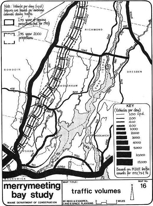
Map 16 shows diagramatically the relative volumes
of traffic on all the more important roads in the Bay area. The
traffic volumes on the rural access roads average somewhere between
100 vehicles per day to 400 vehicles per day.
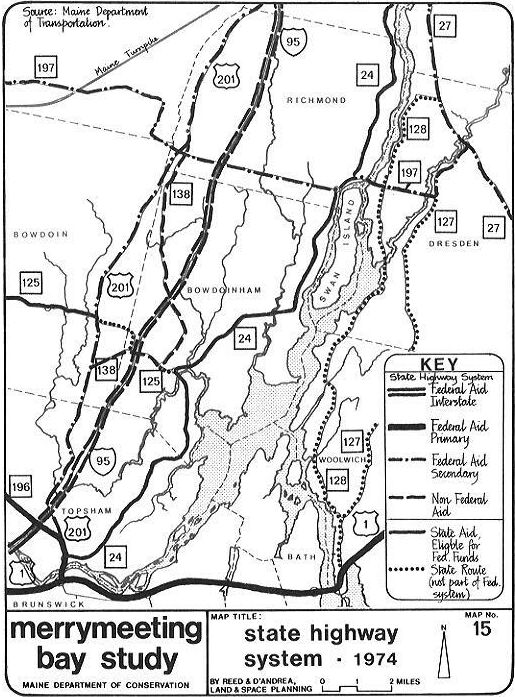
The State Highway System
Map 15 shows the extent of the State Highway
Systems around Merry- meeting Bay in 1974. Five categories of highway
in addition to the Maine Turnpike are involved; the categories are
based primarily on the roads functional classification as well as the
volume of traffic carried, the lane width, and the extent of Federal
and State Aid applied. The map only shows the State Highway System
(made up of Federal Aid, Interstate, F.A. Secondary, and non-federal
aid roads that are part of the system) and State-Aid roads that also
are eligible for Federal Aid. The map thus does not show all
State-Aid roads.
New Highway Construction
The significance of the extension of I-95 from Topsham to Gardiner
some four miles west of the Bay and now under construction is
considerable. In the past the Bay has been a "backwater" in terms of
its regional accessibility; neither the Maine Turnpike nor Route 1
serve it directly. In the future (the highway is now planned for
completion in 1976) this will change; the Bay will be regionally
accessible. Major intersections are being built at Topsham,
Bowdoinham, Richmond, and Gardiner (see diagram on following page).
The stretch of I-95 between Route 201 in Gardiner and the Turnpike is
now complete and open to traffic. It should be noted that I-95 has
been complete to Brunswick for some time and that the southern edge
of the Bay has had the benefit of this access for some time.
The new highway is designed as a scenic, divided highway with two
lanes in each direction. Obviously as it duplicates Route 201's
through function, I-95 will siphon off much of this traffic as well
as a considerable portion of trips destined for Augusta from Portland
land vice versa) that would presently use the Turnpike. In fact, the
new I-95 will shorten this distance by five miles and save drivers
75ó in toll fees.
Design studies by the Maine Department of Transportation show that in
the year it opens I-95 should have over 8,000 vehicles per day. Their
projections for 1990 show volumes of over 17,000 vehicles per day; in
the year 2000, volume will be in excess of 22,000 vehicles per day.
The implications these high traffic volume figures have on the local
town roads that intersect with I-95 are interesting. For example on
Route 197 at Richmond where the present vehicles-per- day figure is
1,265; it is expected to be 1,430 vehicles per day when I-95 is
opened and 2,350 vehicles per day by 1990; almost twice the present
volume. On Route 196, the present vehicles per day figure is 6,825;
with the opening of I-95, it is projected to jump to 7,640 vehicles
per day and by 1990 the projections show 12,000 vehicles per day, or
about 1,200 vehicles per hour in peak periods.
The figures and table describe the Department of
Transportation projections more precisely. It should be noted that
these figures do not take new traffic, generated by highway-related
developments, into account; the volumes are also tentative and
subject to adjustment with the availability of new traffic and
socio-economic data according to the Department's Bureau of
Planning.
A review of the Department of Transportation's 1974-75 Highway
Construction Program shows that little other important new construc-
tion is planned for Sagadahoc, Cumberland, or Lincoln counties in
areas near the Bay. The most significant project listed concerns
engineering studies in Topsham on Route 196 near the Lisbon town
line. Studies were evidently made necessary by the high increase of
traffic in recent years on that route. The few other improvements
planned are all so-called "stop-gap improvements" necessitated by
inflationary trends in the highway construction industry and the
Department's established budgetary resources. The 1976-77 Highway and
Bridge Improvement Program by Maine Department of Transportation
lists only one improvement in the study area, the replacement of the
Abagadasset Bridge on Route 197 in Richmond.
The Implications of Increased Traffic
It is difficult to project traffic volume figures and their impli-
cations when the whole question of gasoline and its availability is
the subject of considerable speculation. Until the so-called energy
problem is resolved and clear policies are defined, traffic projec-
tions will be contingent on day-to-day occurrences in the global oil
situation.
Nevertheless this country's heavy reliance on the automobile is sure
to continue and the demand cars put on roads, both in terms of
maintenance and improvements, will likewise increase. The patterns of
development around the Bay reflect this same reliance on the car. New
housing is being built further from the village centers and the
automobile and the rural road system serve to link the two.
Unless the impact of the automobile is planned for and controlled in
the Merrymeeting Bay region (and elsewhere in Maine), the people and
the environment will be dictated to by this machine rather than vice
versa.
It is important to recognize that most traffic and road construction
planning is done reactively; conditions worsen until they reach a
point where a plan to solve the problem is required. What is needed
are policies at both the local (town) and state level that address
the issue of growth (where it should occur, when it should occur, if
it should occur) and transportation plans that implement these
policies. Admittedly such thinking may be difficult to achieve now,
but to react to growth rather than to plan for it is to lose sight of
the fact that man does have control and should not be dictated to by
his creations.
The table on the next page shows traffic volumes and projections on
some of the principal roads in the Bay area. The projections by the
Maine Department of Transportation take the impact of the new I-95
into account and show that traffic volumes are likely to increase; in
one instance by as much as 500% (on Route 196 between 1950 and
1990).
Increased traffic can "spin-off" highway related development,
especially at key intersections. Garish signs, gas stations, motels,
and fast food type operations are ofttimes associated with important
highway intersections. This is not to say that like facilities will
occur at every I-95 intersection but it does suggest that the towns
preempt any such uncontrolled development by preparing adequate
zoning and sign controls.
Similar controls should be instituted on those roads linking the I-95
intersections with the villages of Topsham, Bowdoinham, and Richmond.
Strip-type commercial development could occur on these roads which
would be better concentrated in the village or at the
intersection.
Increased traffic using I-95 may well be supplemented by increases in
tourist traffic. The informative "Tourism in Maine" study showed that
sightseeing is the most popular tourist activity. It also showed that
congestion is occurring along the coast during the peak tourist
season, and went so far as to suggest that the state adopt a policy
of encouraging four-season tourist attractions further inland. The
implications this has on the study area are twofold; first, I-95 is a
logical route from the coast inland, and second the Bay itself could
conceivably become a tourist sightseeing attraction, although the
recreation studies argue against it. Both of these could result in
more traffic.
If all this points to more traffic, it is important that the positive
"spin-off" effects be captured and that the negative effects be
eliminated or at least reduced to a minimum. The paragraphs below
describe what the effects may be and how it may be possible to deal
with them.
- I-95 will create noise pollution especially from heavy truck
traffic.
--Zone a 250-foot strip of land on either side of the highway as a
buffer and prohibit development there (for visual as well as noise
protection reasons).
--Research efforts by the Federal Environmental Protection Agency to
regulate noise generated by highway uses and take reasonable actions
to control excessive noise.
- I-95 intersections with local roads will make land in the vicinity
desirable to development.
--Control development through new zoning and/or outright purchase (by
town or a community development corporation or a regional
authority).
-- Increased traffic on some local roads will encourage new strip
development along them. If this is not considered by local planning
and land use controls, traffic conflicts and accidents will
increase.
--Establish at the town level a hierarchy of roads based on present
and projected traffic volumes and set up standards to control the
distance between entrance driveways, setbacks, signs, speeds,
etc.
--Set standards to control access and egress on new develop- ment
based on traffic volumes and road frontage with the D.O.T.
--Zone to eliminate strip-type development.
- Increased traffic will necessitate higher maintenance costs (street
repairs, resurfacing, plowing) and will possibly mean the provision
of street lights and traffic signals.
--These costs should be taken into account by each town as they
represent the costs of growth; they imply higher taxes that either
have to be borne by the community at large or by those businesses
locating on and profiting from a high traffic volume road.
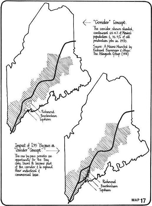
On a statewide scale, it is worthwhile looking at the "Corridor
Concept" put forward in A Maine Manifest (Barringer et al. 1972)
because this concept is based on the fact that growth and employ-
ment opportunities are spun off by a regional access corridor-- the
Maine Turnpike. A glance at the "corridor" of towns identified in
that study shows the Bay area towns conspicuously unaffected. Yet
I-95 between Brunswick and Gardiner could change this and extend the
"corridor" to the towns of Topsham, Bowdoinham, and Richmond, in the
study area (see map) and Gardiner. Gardiner, in
fact, has announced an industrial park development and shopping mall
proposal for the intersection of I-95 and Route 201. While the market
for the latter has been questioned the idea of establishing develop-
ments that could make prime use of the regional accessibility offered
by these locations should be pursued. Regional distribution centers,
truck terminals, and warehousing, research and development offices,
motels, etc., immediately come to mind.
Bus Service
The Merrymeeting Bay area is served by three local bus companies and
the national Greyhound bus system. Greyhound operates a coastal route
that stops in Brunswick and Bath. This route links these towns with
Bangor, Rockland, and Portland from whence it links with the
company's national network. Some four buses per day run from
Brunswick to Portland and two per day from Brunswick to Rockland.
There are none directly connecting Brunswick and Augusta.
The three local transportation companies provide a variety of
services, none of which are significant in terms of a public
transportation system for the area. They are essentially small
operations serving a very small market.
Bath Bus Service has 12 buses, five of which operate as school buses.
The firm does some charter work and provides a single morning and
evening bus run through the town; this is essentially for Bath Iron
Works employees.
Brunswick Transportation Company owns about 40 buses. Twenty-five of
these are used primarily for charter work; for example, the company
offers package tours out of state and in the summer operates a one-
day coastal tour. A five-days-a-week service is provided between
Richmond and Brunswick; a single morning and evening bus on this
route is used mostly by Richmond and Bowdoinham residents working in
Brunswick.
The South Gardiner Baptist Church also provides a weekday service to
Bath Iron Works employees from Gardiner via Richmond, Bowdoinham,
Topsham, and Brunswick. This service consists of two buses in the
morning and single buses in the afternoon and at night. These serve
all three Bath Iron Works shifts.
Air Transport
The nearest Maine airports to Merrymeeting Bay with scheduled
passenger service are those at Auburn-Lewiston, Augusta, and
Portland. These are served by Air New England and Delta tat
Portland). Connections in Boston and New York allow air travellers to
fly to all major cities. Also significant to the Bay area are a
number of small fields for general aviation use. Some of these fields
offer such service as 6-16 sightseeing flights, general charter,
maintenance, instruction, and fueling. Those fields listed in the
area by the Federal Aviation Administration office in Augusta
include:
Douglas Field, Brunswick (privately owned and completely
inactive)
Enman Field, Brunswick (privately owned and for private use only)
Bradley Field, Topsham (privately owned and for private use only)
Davis Field, Topsham (private and now closed)
Merrymeeting Airport, Bowdoinham (turf, commercially licensed, public
use)
Wiscasset Airport, Wiscasset (paved, commercially licensed, public
use)
These last hue airports are inspected by the Maine Bureau of
Aeronautics to assure compliance with minimum safety standards.
Some 4,000 take-offs and landings of local aircraft are recorded
annually at Merrymeeting Airport. An additional 1,500 itinerant tout
of state or non-local) flights were recorded in 1974. The Wiscasset
field had about 12,000 take-offs and landings and 5,000 itinerant
flights during the same period.
During the peak months of July and August, some 600 flights were
recorded at Merrymeeting field and 2,000 per month at Wiscasset.
Thirteen planes are regularly stationed at the former field and
twenty-eight at the latter.
A single private seaplane operates out of Topsham and uses the
Androscoggin River for take-offs and landings.
Brunswick Naval Air Station, located just south of the Androscoggin
River and Route 1 and east of the center of Brunswick, is the largest
airport facility in the Merrymeeting Bay area. This military
installation has an average of 100 take-offs and landings daily or
about 35,000 annually. Noise pollution from the Naval Air Station has
not been taken into account in either Brunswick's or Topsham's zoning
code, although population density and building height restrictions
are found in the Brunswick code. Both towns should compute the
Composite Noise Rating for the airport and enact land use controls
that recognize that certain land uses (especially single-family
houses) be prohibited where noise frequencies could be detrimental to
the public's well-being.
Whereas the present numbers of take-offs and landings at the small
fields around the Bay are such that no noise controls are apparently
necessary at this time, the towns should be aware of this potential
problem should flights increase. Adequate safety precautions in the
direct line of flight approaches and take-offs are needed and these
should be incorporated into each town's zoning regulations.
Rail Service
The Maine Central Railroad Company operates two lines in the
Merrymeeting Bay area. From Brunswick one line heads east through
Bath to Rockland; the other heads towards Augusta and points north,
generally following the west bank of the Kennebec River.
There is daily freight service (except Sundays) to Brunswick, Bath,
Topsham, Bowdoinham, and Richmond. No lines serve Bowdoin or Dresden.
Sidings are located in all the towns served with the exception of
Topsham.
In correspondence with the Railroad's Industrial Development, Real
Estate, and Taxation Division, this office was told that Maine
Central has no plans to phase out any of its freight operations in
those towns presently served. In addition, the railroad feels that,
if the topography is suitable, sidetracks could be constructed to
serve any future industrial park or development.
Apparently the prospects for reintroducing passenger service on Maine
Central is nil and it is only remotely possible that AMTRAK would
initiate such service possibly in 1977 and then only if the rail bed
is improved.
Public Transportation Summary
The chapter on Roads and Traffic and the implications of increased
traffic need little further discussion. It is quite evident that the
automobile will continue to be the prime mode of transportation and
that plans to control and direct its impact on the environment are in
order.
Bus service in the Merrymeeting Bay area is minimal. There are some
nine bus trips per day serving primarily Bath Iron Works employees
and Greyhound has an intercity service along the coast. The state's
Department of Transportation is presently studying public transit
service in Maine with a view toward upgrading rural mass
transportation with the use of Mass Transportation Program Funds.
Should the Bay region itself identify a need for improved bus
service, grants from the federal government could become available.
The federal share for capital equipment assistance would be 80%; the
local share of 20% could be from state, regional, or local
sources.
Air transportation as such is not significant to the Bay area,
although the noise factor from take-offs and landings at Brunswick
Naval Air Station should be a consideration in future land use
planning there and in Topsham.
Finally, rail transportation,. while offering no likelihood of
passenger service does provide some of the Bay area towns with
freight service. In addition, future industrial plants located on or
near existing tracks could be served by sidings.
A report entitled "Sewer and Water 1970" by Community Planning
Services and prepared for the Bath/Brunswick Regional Planning
Commission is the main source for this discussion on water
supply.
Richmond, Bowdoinham, Topsham, Brunswick, Bath, and Woolwich have
water supply facilities servicing their central areas. Water service
for the outlying rural areas is from private dug and drilled
wells.
Map 18 shows the extent of service provided by
existing pipe systems in these towns and also illustrates the extent
of planned future lines.
Bath and Woolwich share a water system which derives its supply from
Nequasset Lake. In Woolwich the pipeline follows Route 1; it crosses
the Kennebec on the Carlton Bridge and then extends north and south
paralleling the river. Recently the system has been extended to the
north to serve a new housing development there.
Evidently two top priority goals for this area are: the provision of
a second river crossing as a back-up supply, and the interconnection
of the Bath system with the Brunswick and Topsham water districts.
This latter goal would help provide service to expanding development
between Bath and Brunswick.
Brunswick's water-supply lines follow Route 1 and include a number of
extensions that run west, north, and south of the central area.
Topsham's water supply lines serve its downtown and most buildings
within a mile radius of downtown.
Bowdoinham's water service has recently been extended and serves
northeast of the village along Route 24. Other lines serve the
village area, a portion of Route 125 and 138, and some 2,500 feet of
Route 24 south of the village. The report, Bath-Brunswick Region and
DD 963, states that the sources and reserve supplies are, "at
minimum, five times as large as are needed" (Varhol 1969).
Richmond's water supply is pumped across the Kennebec via Swan Island
from wells located in Dresden; it supplies about 540 customers. Only
the immediate village area is served although one line does extend
west along Route 197 for a distance beyond the village itself.
Dresden has no municipal water supply and all buildings have private
well supplies.
Only the urban built-up portions of the larger Bay towns have
water-borne sewage systems serviced by treatment plants. Bowdoinham,
Dresden, and Bowdoin do not have plants and like the majority of the
more rural areas rely primarily on septic tanks for their effluent
disposal.
About 90% of urban Bath is sewered. A treatment plant has been built
at the north end of the town and, according to the Community Planning
Services report, all sewage should be receiving secondary treatment
by 1976.
Brunswick's sewer system serves much of the built-up area. The whole
system is presently being upgraded and secondary treatment is
replacing the existing primary system.
Topsham's sewer district is limited to the central downtown area. At
present the raw sewage is discharged into the Androscoggin, however,
the construction of a sewer main under the river to link the system
to Brunswick's treatment plant will eventually alleviate this
condition. Construction is only expected to begin in 1976.
Richmond's sewers serve the village area only. The town's primary
treatment plant is located on the Kennebec; however, it cannot handle
the town's combined storm and sewage water system. This situation is
presently being corrected and is in the planning stages. The map on
the following page shows the extent of areas in the Bay towns served
by sewers.
Water and Sewer Systems--Future Prospects
As is evidenced by the preceding and illustrated on the maps, the
larger Bay area towns urbanized districts are well served by sewer
and water systems, Pollution abatement can and probably will be
achieved through the upgrading of the existing plants and future
demand for sewer service in these urbanized areas can be accommodated
to within the limits of the plant's capacity.
Future problem areas concerning pollution control and abatement are,
therefore, much more likely to occur in those areas outside the town
centers. This represents the overwhelming majority of land in the Bay
area. In these areas individual septic tanks are the predominant form
of sewage disposal, although "package" treatment plants and special
designs are also utilized. The new (1974, rev.1975) State Plumbing
Code establishes standards for acceptable types of small treatment
facilities. The code permits use of a wide range of small sewage
disposal systems and the standards are strict. The problem, however,
lies in enforcing these standards as this responsibility rests with
the local municipality where the expertise and financial resources to
carry out this mandate are less than optimal. The level of expertise
required to monitor the larger private package treatment plants is
often beyond the capabilities of the small towns. In the opinion of
the Bath/Brunswick Regional Planning Commission consultants a
"regional pollution control district" is called for to deal with this
problem. The consultants make the following points concerning such a
district or agency:
Emphasis would be on management rather than control Membership would
be at the option of the local community The district would be staffed
by trained operators who could serve the whole region Installation of
all septic tanks would be overseen by the agency The agency would act
to advise developers of the best system for their use The district
would act as a central purchasing body and source of equipment
Operating expenses would be met by assessment against population
served.
Any such "regional pollution control district" would require enabling
legislation. Another effort directed toward more effective
enforcement is being considered by the State Planning Office. They
are seeking to establish an office for a regional code enforcement
officer--an expert who could assist communities in dealing with,
among other tasks, the enforcement of the State Plumbing Code.
Apparently there is little concern over the adequacy of existing
sources to supply sufficient water to the Bath/Brunswick region; yet
the consultants suggest that "mini" water supply systems be developed
by a public authority to supply groups of houses--the number of homes
served being dependent on the supply. This is seen as a better
alternative than the gamble an individual well represents to every
homeowner.
The map on the next page shows the extent to
which electrical power lines intrude on the Merrymeeting Bay area.
These lines are a fact of life. In many places they dominate the
skyline and to boat users they are particularly visible. They are
visually unattractive and the wires are known to be a hazard to bird
life especially where they span the Chops and Abagadasset Point--once
two of the most attractive locations on the Bay.
The right of way strips for the power lines do, however, provide
habitat for upland game species and hunters do utilize the long sight
lines these strips provide in deer season. In winter snowmobiles also
make use of these rights of way. Central Maine Power Company permits
these uses but does not sanction them on the official level.
Little can be done to lessen the visual impact created by these
towers and high tension power lines. The right of way strips can,
however, be maintained to ensure cuttings and slash. are not piled
randomly and obtrusively and certain low or no maintenance ground
cover could conceivably be planted. Placing transmissions lines
underground is prohibitively expensive according to a Federal Power
Commission report, the cost being forty times that of overhead
lines.
A report produced for the New England Regional Commission titled
"A Study of the Electric Power Situation in New England 1970-1990"
contains a few points that bear repeating. First, a fourfold growth
in power requirements over the next 20 years is forecast. The basis
for this forecast is not made clear in the report; yet it seems
ridiculous that, given the energy situation in this country and the
fact the population is not going to quadruple, this much demand is
estimated (see Zinder and Assoc. 1970).
The report further states that New England and especially Maine is
fortunate to have a cold-water ocean into which excess heat can be
disposed. This means that future power plants locating on the coast
east of the Bay may well locate new lines near or across the Bay.
The Wiscasset nuclear plant is one such existing example. At present
another plant is planned for Sears Island; according to Central Maine
Power, current plans for the right of way lines from this facility
will be located near Waterville (correspondence with CMP, Feb. 19,
1975).
At present Central Maine Power is known to have options on land on
the Kennebec River in Richmond. A new nuclear plant is a possibility
here and, irrespective of the effect such a plant would have on water
quality, it would certainly be the source of further transmission
lines stretching both east and west.
The negative impact radioactive waste emissions would have, through
accident or design, from the Wiscasset plant or a possible Richmond
plant on life in the Merrymeeting Bay region is beyond the scope of
this report. The University of Maine and the Maine Yankee Atomic
Power Company prepare annual "Environmental Studies" which report on
surveys conducted around the Wiscasset plant.
A study of the size of land parcels in the Merrymeeting Bay Study
Area reveals a distinct pattern. First, the majority of land is in
parcels of 50 acres or more. Second, the smaller parcels (30 acres or
less) tend to be clustered around the urban village centers and along
the major roads that link these centers. These patterns reflect both
historical and present day trends. Historically the majority of rural
land was farmland, today this shows up on the map as the predominant
plus-60 acre parcels. Present day trends, however, are towards the
cutting up of these larger farms, especially on those roads that
provide quick and easy access to places of employment. Hence, the
pattern of smaller lots.
There is no distinct pattern to land parcels with frontage on the Bay
and its tributaries. There are, however, few large parcels, the
average size parcel being about 20 acres. Where local roads are
located close to the Bay shore the lots are smaller yet. This is most
noticeable where Foreside Road and the Old Bath Road parallel the
Androscoggin River shore. The very smallest lots with shore frontage
occur at the mouth of the Abagadasset east of the Foreside Road south
of Pleasant Point and west of Lines Island off the Varney Mill
Road.
It is evident from the above that where access to the Bay shoreline
is made easy, more subdivision and small lots occur.
Seen on a town-by-town basis, and again referring solely to those
parcels within the confines of the study area, the following
observations can be made: In Bowdoin in the Cathance Valley, about
80% of the land parcels are over 60 acres in size. Parcels around
Bowdoin Center on Route 125 average between 1 and 15 acres and the
same is true of land on the Meadow Road immediately north of the
Topsham line. The pattern of smaller holdings (5 to 30 acres) along
town roads that is so typical of Topsham, Bowdoinham, and Richmond is
not prevalent in Bowdoin either along Route 201 or the Meadow
Road.
Since the forces of growth and change (most notably the automabile,
the present small scale building and development companies and the
nature of zoning) that have produced the above-described ownership
patterns have not changed, it is reasonable to predict that large
lots--particularly those along the town roads and fronting on the Bay
and its rivers--will continue to be split up into smalleu lots. Such
a pattern, if left unchecked, could produce mile upon mile of small
lots. Not only would this kind of development change the rural
character of the landscape but it is unwise in terms of traffic
safety, the provision of services, and in terms of the efficient use
of land.
In order to determine current real estate trends in the
Merrymeeting Bay area, a telephone survey with knowledgeable real
estate persons was conducted in February 1975. In all, ten agencies
were contacted and were questioned about current general trends and
properties for sale. The results of these direct questions regarding
land and prices are tabulated and mapped on the following pages. It
should be pointed out that the locations of the properties on the
map are not precise and that the prices quoted
are asking prices.
The interviews and an analysis of the properties for sale indicate
the follawing:
--There has been marked increase over the recent past in the
desirability of Bowdoinham and Richmond as places to live. Good
access (by way of I-95), good prices (as compared with
Bath/Brunswick area), and the benefits of rural/village living were
cited as reasons for this.
--During the last six months (Aug.1974-Jan.1975) there has been a
temporary lull in purchases in the Bay area as compared with coastal
property. The reason offered is that the very rich, who can afford
coastal property, have not been affected by the recession whereas
those interested in Bay property have.
--Evidently the quality of water is an inhibiting factor on some
shoreland sales. Real estate agents feel that, propeuty will be more
desirable once the quality of the Bay water is upgraded. This was
especially true of land bordering the Androscoggin River .
--There appears to be no per-foot-price formula that can be applied
to shorefront land. Nevertheless, shorefront property is obviously
valuable and the asking price on lots of about 14 acres averaged
around S1,QOO/acre (based on three properties, two on the Kennebec
and one on the Eastern River).
--Land values at the intersections of I-95 range from $400 to
$500/acre (based on information obtained for two large tracts
only).
--Land subdivided into one-acre lots on the Androscoggin off Foreside
Road and just east of the village of Topsham is presently for sale at
prices ranging fram $7,000 (for inland lots) to $16,000 (for
riverfront lots). There are unimproved lots. There is reason to
believe that these high prices will set a precedent for similarly
located property.
--Large wood and farmland parcels in Dresden list at about
$300/acre. Prices for similar land west of the Bay tin Bowdoin, for
example) list at about the same per acre price, indicating, perhaps,
that I-95 has not affected large parcel land prices to any
appreciable extent.
These statements speak for themselves, It is obvious that a range of
types of property is on the market and that both large and small
parcels are available (the survey did not record "in-town" or village
property values and looked only at rural land). It is also evident if
one looks at comparable land prices for, say, five years ago; that
farm and rural land values have increased substantially. U. S.
Department of Agriculture figures show that this is true of farm
prices nationally; farm real estate values increased 13% in 1973
alone for example.
 TABLE 6-3
 REAL ESTATE PRICES* (1975)

Property**	No. of
Location	Acres	Price $	Comment
1	155	110,000	Land and old farm 1/2 mile E of 201.
2	225	50,000	Cut over woods and fields N of Beedle Road.
3	100	40,000	At intersection with I-95 (not zoned for commercial use)
4	80	25,000	oodlot in Bowdoin on Route 20.
5	12	14,000	Land with 600 feet frontage on Kennebec.
6	40	26,000	Land with 400 feet frontage on I(ennebec.
7	14	43,000	Old house and barn on Kennebec.
8	90	30,000	Woodlot on Route 201.
9	50	30,000	Old farm on Route 138 and I-95.
10	3	28,000	Service station and mobile home on 201 at 135.
11	100	70,000	Cape with barn on Meadow Road.
12	8	39,500	Cape on Meadow Road.
13	1	30,000	Hunting Lodge on Muddy River with views.
14	60	75,000	Land on Pleasant Point.
15	10	115,000	Large colonial house and 3 cottages, 1200lBay.
16	12	55,000	3 bdrm. house on Foreside Road.
17	10	55,000	3 bdrm. new house on Foreside Road.
18	14	55,000	4 bdrm. house on Foreside Road w/560' frontage.
19	1	+10,000	Various lots. Price range $7,500 to $16,000.
20		27,000	Condominium apartments on River Road (48 units)
21	4	25,000	Land on Blackwater Point, 600' frontage.
22	200	125,000	Overlooks, but not on Bay.
23	12	85,000	3 bdrm. house with 4000' frontage on Bay.
24	84	25,000	Woods and farmland in Dresden near Route 127.
25	25	8,000	Woods and farmland in Dresden near Route 127.
26	44	15,000	Woods and farmland in Dresden near Route 127.
27	3.5	6,000	Frontage land on the Eastern River,
28	13	12,000	200' frontage on the Eastern River.
29	15	20,000	900' frontage on the Easten? River.
30	1	32,500	Restored colonial farmhouse in Dresden Mills.
31	60	60,000	House and land with Kennebec River frontage.
32	40	42,000	House and land with Kennebec River frontage.

 * The prices listed are asking prices quoted by various real estate agents.
 These figures were obtained in a telephone.survey conductea in Feb. 1975,
 *x See Map No. 20.

 TABLE 6-4
 BUILDIG PERMIT DATA 1970 - 1974
 Mobile Homes and Single-Family Homes

		1970	1971	1972	1973	1974	Totals
Town		MH SF	MH SF	MH SF	MH SF	MH SF	MH SF
Bath		16	1 18	4 5	1 10	17 46	23 95
Bowdoinhaml	10 ?	10 10	10 10	10 12	12 32	52 64
Bowdoin*
Brunswck2	16 31	18 36	14 5a	8 48	6 42	62 215
Dresden*3		9				9
Richmond4	? 2	? 8	12 15	? 26		12 51
Topsham		14 35	20 69	15 75	14 34	17 46	80 259
Woolwich*
TOTALS		40 84	58 141	55 16S	33 130	52 166	238 684

 Notes:
1. The figures for Bowdoinham between 1970 and 1972 are estimates.
2. Brunswick built 48 townhouses in 1973
3. Thirteen new homes were built in Dresden between 1967 and 1971 and 9 mobile homes were located in the town in 1971.
4. The average new home value in 1973 was $23,000 in Richmond.
* Figures not available.
Two large mobile home parks, Bowdoin Terrace and an extension to the
Crooker park on the Old Bath Road,have been approved. Together these
two recent developments will provide about 307 new mobile home lots.
Both are located out of town in rural areas and depend on "packaged"
private sewage treatment plants.
The residential subdivisions recorded in the state files are Sherred
Village in Bath, Parkview Estates: in Brunswick, and the Barrows
subdivision in Topsham.
It is evident from the foregoing that development in the Bay area
occurs on a small scale with few large "developments" occurring. It
is also clear that most of the construction is residential in
character.
Interviews with a number of building contractors who operate in the
Bay area towns reinforce the above-mentioned findings. The main
points brought up by builders were:
--most construction is residential in nature, much of this occurs on
one- to two-acre rural lots; the remainder is on smaller lots
typically served by a public sewer as against a private septic tank
system.
--the majority of builders serving the area operate on a small scale;
few build more than ten units per year and most average from 4 to 6
homes.
--these builders build both on private lots for a particular client
and on lots they acquire themselves.
--all builders interviewed saw the Site Location Act as a hinderance
to their activities and felt that its existence would help ensure
that the scattered, one-lot-at-a-time, type development that
presently characterizes the area would continue.
--the Manufactured Housing Association foresees an increase in the
number of double-wide mobile homes and modular housing units, yet
some builders were of the opinion that this type of unit was not
acceptable to all.
--many of the aingle-family homes now under construction are being
financed throuh Farmers Home Administration loans at a cost of
between $25,0a0 and $28,000; little bank financing is available.
--few builders expressed much optimism about the current slw;np in
the construction business and there was a reluctance to speculate on
the future.
It is interes.ting to compare the ahove findings with those oS t3he
state as a whole for 1973-1974. In an October 1974 report by Sherman
Hasbrouck of the University of Maine, Orono, titled "Indicators of
Housing in Maine 1974;" the following general statements occur:
--despite the current inflation and rising interest rates the volume
of new housing is continuing at a strong pace--compared with the pace
in the 1960s.
--privately financed new home construction has dropped sharply.
--the Farmers Home Administration has become a major factor in new
home financing (see Table 6-5).
--new mobile home purdnases are down 7 to 10% since 1973.
In another study "Program Potential in Housing" prepared for the New
England Regional Commission by Real Estate Research Corporation the
nature of the housing industry in the Brunswick area is described in
this way:
There is no real housing industry...ln the Brunswick area for
instance, 'large'' b.uilders were considered to be those who produced
10 to 20 units a year, and of these there were only three that could
be identified.
 TABLE 6-5

 NEW HOUSING IN MAINE 1970-1973

		Av. Annual New				1973
Housing Type I	Housing 1960-69	1970	1971	1972	(Estimate)
Mobile Homes	1500		4000+	3400	3100	3400
Conventional Homes
Famers Home	200		400+	800+	1000+	1000
FHA & VA	200		250	400	400	300
Other		2600		2850+	3000+	3500+	3000
TOTAL		4500		7500	7600	8000	7700

 SOURCE: Resource Development Highlights No. 6,1973. University of Maine, Orono.
The preceding chapters on land ownership patterns and real estate
and development trends demonstrate that growth is occurring in the
Merrymeeting Bay area at an accelerated pace. This is a product of a
host of factors not the least of wich is the presence of I-95. Of
particular significance is the haphazard yet relentless growth of new
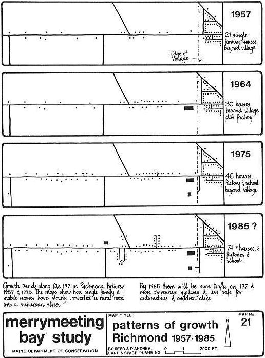
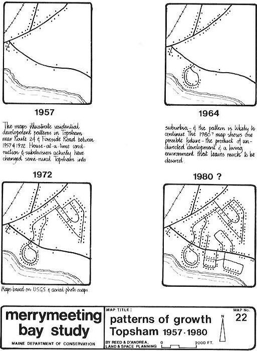
Yesidences on the so-called rural fringe. Maps 21 and 22 illustrate
this fact.
The desirability of rural living and rural lots is easily understood.
In citizen surveys conducted in the towns of Richmond and Bowdoinham,
the desire for a "small town atmosphere" was prevalent (as was the
desire for slow growthr Richmond and Bowdoinham Planning Boards 1974
and 1975). Real estate persons interviewed reiterated this sentiment
saying that many seek country living and commute to urban jabs. At
the national level, surveys also show that people tend to prefer
smaller communities (Assoc. of State Planning Officials 1972).
Thus many in the Bay area seek and put a premium on the quality of
life offered, yet as the maps illustrate, that goal is ofttimes
thwarted by haphazard, unplanned growth. Development in the Bay area
has occurred and probably will continue to occur in a piecemeal,
leapfrog fashion. Yesterday's rural route with a few scattered farm
houses and new homes invariably becomes a linear suburbia.
It is evident that the pressure for growth will continue. The
question is how can new development be guided to ensure the "quality
of life" that is desired will be enhanced by, rather than destroyed
by, succeeding single houses or subdivisions.
The answers are not straightforward. First, the whole issue of the
desirability of unarrested growth must be faced. Communities can, as
they traditionally have, fling open their doors to all comers (thus
hoping to enlarge their tax base), or they can act to slow
growth.
Second, once a desired growth policy and rate of growth is defined,
they can seek ways to guide that growth to the most desirable areas.
Zoning and subdivision laws have traditionally attempted to fulfill
this function and, as the record shows, have largely failed.
Controlling the Rate of Growth
The pressures for growth and change have come late to the
Merrymeeting Bay area; it was relatively dormant during the 1960s, a
period of great change in this country. In those years two maxims
were touted: "Growth is inevitable" and "Growth eguals progress"
(Assoc. of State Planning Officials Planning Advisary Service
1972).
Traditionally, planners have simply tried to predict, through
population projection, what the "inevitable" levels of growth would
be, and then sought ways to accommodate it according to a "Plan."
This methodology has been questioned of late. The growth equals
progress or "more is better" syndrome has also been questioned. "Our
country can no longer afford the uncritical acceptance of the
population growth ethic that 'more is better'" states the U.S.
Commission on Population Growth and the American Future in its
report,Population and the American Future (1972). That same report
goes on to say..."we find no convincing economic argument for
continued national population growth. On the contrary, most of the
plusses are on the side of slower growth."
The attitude in the past has thus been that plans should accommodate
growth pressures no matter what rather than be policy statements that
set standards for a desirable quality of life. In the 1960s, the
planners were forever trying to catch up; now many are talking about
defining a desirable future and encouraging and influencing only that
development that helps achieve those ideals. Current terminology
describes this as "managed growth."
Since the concept of managed growth is relatively new, it has not
been fully tested. However, a number oflegal vehicles present some
possible means for growth control. Bowdoinham, for example, has a
moratorium in effect while its comprehensive plan and zoning
ordinance is being drafted. The moratoriun is thus an effective,
albeit temporary, means of slowing growth.
An alternative to zoning has been proposed for Fairfax County,
Virginia. Named Transferable Development Rights, this con.cept to
control growth uelies on the adoption of a desirable growth plan and
the establishment of potential development rights for residential,
commercial, and industrial uses. These rights are allocated to all
property owners on a per acre basis within a defined growth. area,
Developers then purchase rights from landowners. The usefulness of
this system in the Bay area now is, however, questionable. It
requires a large professional staff and is geared more to the large
scale development practices of suburban Washington, D. C., than to
the smaller scale of the Bay towns. It might have more validity weire
a regional form of government in effect.
Perhaps more in scale with the present Merrymeeting Bay situation is
the idea of controlling development through the location of needed
public services, principally sewer and water service. Boulder,
Colorado, has, for example, established a "blue line" beyond which
water service cannot be supplied; the purpose there is to protect a
scenic landscape from being urbanized. It would certainly be to a
town's financial advantage to keep the service area limited to a
neighborhood rather than strungout over miles of linear roadway (see
also Mace and Wicker 1966; Real Estate Research Corp. 1974; McKee
1969; Isard and Coughlin 1957; Muller and Dawson 1972).
The judicious acquisition of open space by a town (through bonds or
sales taxes, perhaps) can also be used to guide growth to a degree,
as could acquisition at the state level for valued wildlife habitat,
for example.
Controlling growth by not extending utility lines has been attempted
in some communities as have laws that set population limits. Both are
questionable techniques from a legal standpoint because either could
be construed as discriminatory. Growth limitations set by
environmental factors have greater validity yet are hardly applicable
to the low density Bay area situation.
The city of Runapo, New York, has set limits on its rate of growth by
tying develolment timing to the availability of city funds, an
approved capital budget, and a stringent schedule of implementation.l
Upheld by the courts, the Ramapo "timing of development" procedure
has merit. It does,-however, rely on a sophistication in
administration and planning that may be beyond the capabilities of
most of the Bay area towns. Yet, for Bath and Brunswick (possibly in
tandem) it has possible application.
This last point, together with those relating to possible
discriminatory or exclusionary actions, suggests that growth
management should be a regional rather than local concern. Ideally
growth controls should be shapped so that all the local communities
share responsibilities rather than foist them on their neighbors. In
such an arrangement, for example, hazardous yet needed industry can
be located in the best regional location and lower income housing
development can be distributed throughout the area.
Two other concepts for controlling growth that bear consideration
are: Land Banks and Community Development Corporations (CDC). The
concept of a statewide land banking system is discussed in A Maine
Manifest (Barringer et al, 1972); the same ideacould be put into
effect at a regional or local level through a Community Development
Corporation or corporations. Land banking is public participation in
land buying.2 A local CDC would, under this concept, go intobusiness
and "wheel and deal" in land. By purchasing key parcels and retaining
ownership but leasing it they could direct and control
growth--especially if they could offer an infrastructure of essential
utility services.
In sum, it would appear that the towns of the Bay area should
individually or collectively establish definitive growth.policies so
they can grow selectively, slowly, and methodically--in step with the
availability of essential services and funds to provide them. Various
means to achieve this end are available and it is apparent that of
the concepts discussed, land banks, community development
corporations, and utility service restrictions (based on
environmental considerations) offer the best immediate answers and
that the "timing of aevelopment" procedure should be considered in
the long term.
Guiding Growth
Whereas the foregoing discussion has focused on means to control the
rate of grcwth,this section will discuss the means available to guide
grawth in an organized and planned manner. This report has shown that
haphazard growth is both changing the rural character of the
landscape and, because it is unplanned, is creating the very nebulous
suburban type development that the home owners probably were trying
to esoape from in the first place. This is dramatically illustrated
by the diagrams on the following pages. They show, graphically, the
pattern of single-family house development on the fringes of
Richmond and Topsham from
1957 into the 1970s.
In both instances, whether the pattern is a product of single lot
building operations or subdivision activity, the result is the same;
a gradual but all too definite progression towards chaos. In
Richmond, an important connector road (197) between the village and
I-95 is becoming littered with single-family homes, The end
These are some of the reasons why the trends may well continue,
although they do not recognize that: - lot-at-a-time construction ton
a speculative basis) compared to subdividing invariably involves
higher lot costs because the contractor is paying for "frontage" -
savings in sewer and perhaps water costs could be made if the land
were located near to existing service areas - the accumulative effect
of present trends is such that the community looses.and the house in
the country becomes yet another house in suburbia,
What,then, are the solutions? Part is education; the majority of
persons associated with the development process are unaware of the
broader implications of their individual actions. Other solutions
range from zoning regulations designed to reward (or provide
incentives for) developers through a regional planning agency that
could coordinate land provide design review functions) all
development submissions. Some of these are discussed hereafter.
Association for State Planning Officials. 1972. Nongrowth as a
planning alternative. Repo+t No. 283. ASPO, Chicago. 65 p.
Barringer, Richard, et al. 1972. A Maine Manifest. The Allagash
Group. Tower Publishing Co. Portland, Maine. 23 p.
Bowdoinham Planning Board. 1975. Bowdoinham's comprehensive plan.
Town of Bowdoinham.
Community Planning Services. 1970. Sewer and water, 1970, a report
for the Bath/Brunswick Regional Planning Commission. Bath, Me. 25
p.
Federal Aviation Administration. 1975. Unpublished data on take-offs
and landings at local airports in the Merrymeeting Bay Region.
FAA,
Augusta.
Finkler, Earl. 1972. Nongrowth as a planning alternative: a
preliminary examination of an emerging issue. American Society of
Planning Officials, Chicago. 65 p.
Franklin, Herbert. 1973. Report on legal limits to managed growth.
National Conference on Managed Growth, proceedings. Sept, 16-18,
1973.
Hasbrouck, Sherman. 1974. Indicators of housing in Maine. 1974
Housing monitoring system. Cooperative Extension Service, Univ. of
Mainel Orono. 28 p.
Higley, Bruce. Letter dated February 19, 1955. From Central Maine
Power Company. 2 p.
Isard, Walter, and Robert E. Coughlin. 1957. Municipal costs and
Yevenues resulting from community grawth. Chandler-Davis Publishing
Co., Wellesley, Mass. 111 p.
Johnson, Huey D. 1973. Report on land banks. National Conference on
Managed Growth, proceedings. Sept. 16-18, 1973.
Lamm, Richard D. 1973. Local Growth. IN Equilibriwn, Vol. ,, No. 1.
Jan. 1973.
McKee, John. 1969. Coastal development cost-benefit models. Reprint
from July 1969 issue of Maine Townsman. Public Affairs Research
Center, Bowdoin College, Brunswick, Maine.
Mace, Ruth L. and Warren J. Wicker. 1968. Do single family homes pay
their way? A comparative analysis of costs and revenues for public
services. Urban Land Institute. Research Monograph 15. Washington, D,
C, 47 p,
Maine Department of Health and Welfare. 1974. State of Maine plumbing
code, part II, private sewerage disposal regulations. Dept of Health
and Welfare, Augusta. 60 p.
Maine Department of Transportation. 1972. Traffic flow map. Maine
Dept. of Transportation, Augusta.
Maine Department of Transportation. 1972. Highway construction
puogram 1974-1975. Maine Dept. of Transportation, Augusta. 74 p.
Maine Department of Transportation. 1975. Estimated annual average
daily traffic for I-95 and intersecting routes, 1972-2000. Written
communication, Jan. 23, 1975, Maine Dept. of Transportation,
Augusta.
Maine Department of Transportation. 1975. 1973 Annual daily traffic
flows and 1974 estimates for Merrymeeting Bay area. Written
communication. Maine Dept. of Transportation, Augusta.
Maine Department of Transportation. 1975. Highway and bridge
improvement program, fiscal years 1976-1977. Maine Dept. of
Transportation, Augusta. 32 p.
Maine Yankee Atomic Power Company. 1971. Third annual report,
Environmental studies. Maine Yankee Atomic Power Co., Wiscasset. 2
vol.
Mentz, John. Bnpubljshed paper. Paper concerning reasons for Central
Maine Power Company wanting Richmond as a nuclear site. May 1975.
Muller, Thomas and Grace Dawson. 1972. The fiscal impact of
residential and commercial development - a case study. The Urban
Institute, Washington , D, C. 140 p.
O'Donnell, John E. and Associates. 1968-74 property tax maps for
Topsham, Woolwich, Bowdoinham, and Bowdoin. O'Donnell and Assoc.,
Auburn, Maine.
Real Estate Research Corp. 1971. Program potential in housing
prepared for the New England Regional Commission. April 1971. 162
p.
Real Estate Research Corp. 1974. The costs of sprawl. For Council on
Environmental Quality. U. S. Government Printing Office, Washington,
D. C. 3 vol.
Richmond Planning Board. 1974. Richmond's comprehensive plan. Town of
Richmond, Maine. 45 p.
Sewall, James W. and Co. n.d. Property tax maps for Bath and
Brunswick. Sewall and Co., Old Town, Maine.
Sthal, David E. 1974. Town no-growth stance: repercussions are
predicted. The Washington Postr Sept. 7, 1974.
U. S. Commission on Population Growth and the American Future. 1972.
Population and the American future. New York: Signet, The New
American Library, Inc., and U. S. Government Printing Office,
Washington, D, C.
Varhol, Thomas A. 1969. The Bath-Brunswick Region and DD 963.
Bath-Brunswick Regional Planning Commission, Bath, Me. 25 p.
Wright, Pierce, Barnes, and Wyman. 1975. Preliminary sewer study,
phase one maps. Unpublished. Wright, Pierce, Barnes, and Wyman,
Topsham.
Zinder & Associates, Inc. 1970. Study of the electric power
situation in New England for the New England Regional Commission,
Sept. 1970. 201 P'
Chapter 7