
5.0 OUTDOOR RECREATION
5.1 STATE PLANS
5.2 HUNTING AND FISHING
5.3 BOATING
5.4 SNOWMOBILING
5.5 OTHER RECREATION
5.6 SUMMARY CONCLUSIONS--OUTDOOR RECREATION
5.7 REFERENCES
Despite the fact that Merrymeeting is an important outdoor
recreational resource for many residents of the neighboring towns
and, to a lesser degree, for significant numbers of Maine citizens,
little detailed and documented information as to the numbers of users
and/or types of activities is available. This section has, therefore,
tapped a variety of sources in an effort to focus on current and
future out- door recreation needs and opportunities. (Urban outdoor
recreation is not made part of this discussion as it is outside the
study area,)
At a statewide level, the Comprehensive Outdoor Recreation Plan
(SCORP) acts as a source for some broad-brush recommendations; these
are discussed below. The 1970 Tourism in Maine report provides some
clues as to out of state tourist recreational needs as does the 1973
Open Space Plan. Both these reports are touched on here and
summarized in Section 7.1.
Hunting and fishing are very important recreational pursuits enjoyed
by many Merrymeeting Bay users yet much of the statistical
information on these activities is outdated. Mendall and Spencer's
early (1948- 1.957) studies have been utilized as have Peppard and
Donovan's 1972 migratory bird report and Lewis N. Flagg's (1972)
studies of fishing in Maine but this office's efforts to get up to
date information from local rod and gun clubs through questionnaires
has been thwarted by poor response.
Other information on recreation activities in the Bay area has been
gathered from local residents, a questionnaire sent to snowmobilers,
and from officials knowledgeable in the area. The Bureau of Parks and
Recreation and the Department of Inland Fisheries and Game have also
assisted by providing information available through their files.
The Maine State Comprehensive Outdoor Recreation Plan (SCORP)
addresses recreation needs in the state on two levels; first by
region and, second by day-use area. Eight regions are identified and
the Merrymeeting Bay area falls centrally into Region 2, that area
defined by Kennebec, Androscoggin, Sagadahoc, and Lincoln counties.
Day-use areas are defined as population centers of more than 5,000
people within a 20-mile radius (see map)
Because Region 2 includes coast land and areas beyond the Bay's
sphere of influence as a recreational resource (except for hunting),
it is diffi- cult to make judgments about the Bay itself from the
Plan. Of interest though is the fact that the regional resident
population of over 230,000 persons is doubled during the peak tourist
season. It must again be assumed, however, that the majority of these
summer visitors reside on or near the coast.
The table below lists the main activities of Region 2 in order of
user demand and summarizes the acre land need for each activity for
now and the years 1980 and 1990 as recommended in SCORP (the figures
are accumulative).
TABLE 5-1
ACRE LAND NEEDS IN REGION 2 (1970-1990)

Activity		1970	1980	1990
Swimming		773	1,418	2,618
Boating			1,798	3,285	5,776
Picnicking		3,344	4,825	6,995
Camping			17,650	23,651	32,082
Ice Skating		24	35	50
Hiking			2,856	4,182	6,018
Snowmobiling
Snow Skiing		80	148	259
Nature Trails		357	612	1,020
Horseback Riding	--	--	408
Canoeing		10	10	10

Totals			26,892	38,166	55,236
In sum, the Department of Parks and Recreation recommends that over
55,000 acres of additional land be acquired in the four-county region
before 1990 to fulfill user demand. Thus, if the Bay area towns
represent a sixth of the region (40,000 persons out of 230,000), it
could be construed that over 9,000 acres be acquired in the Bay town
area. The need according to SCORP is primarily for "General Outdoor"
and "Natural Environment" type land rather than that classified as
"High Density" or "Primitive." The Bay area fits the former two
classes rather than the latter. Yet if the activities listed in the
table are viewed separately, it is evident that the specialized and
unique qualities of the Bay itself make many of these uses
inappropriate to a location on or next to it.
The tidal flats make swimming and boating inadvisable and, as most
camp sites rely on these activities as major attractions,
recreational camping is not best located on the Bay shores.
Picnic sites as scenic overlooks are appropriate to a few locations
on the Bay and its roadways and trails for hiking, nature
observation, riding, and in winter, snowmobiling are also suitable
activities for the immediate Bay environs. In addition, some
stretches of the tribu- tary streams are good for canoeing (see
Section 5.3, Boating).
Thus the Merrymeeting Bay area itself does not help meet many of the
needs identified in SCORP. This does not mean that other locations in
the Bay area towns are not suitable for camping and picnicking. There
are areas, particularly in Bowdoin and Dresden or Woolwich, which may
be suitable for these activities. SCORP does not suggest specific
locations where acquisition should occur.
Three day-use areas touch on the Bay but only the Brunswick Day-Use
Area relates strongly to it (see map). Needed
facilities for Brunswick, as identified by SCORP, are swimming areas,
urban trails, and snow skiing. Bath needs a multiple-purpose
municipal park and areas for swimming, picnicking, boating, outdoor
games, nature study, snow skiing, hunting and bird-watching seasons
don't coincide with the peak tourist season. In addition, the Bay
itself is not visible from many places on the roads around it. Some
of the roads are, however, scenic and could provide scenic overlooks
of the Bay. Camping sites, as has been stated, are most often
associated with bathing facilities and/or prime tourist attractions
and as the Bay does not provide either of these it is unlikely that
numerous camp sites will be established along its shores.
Interestingly, the Tourism in Maine report states: "Since 75% of all
hunters and fishermen are residents, half of all state expenditures
for resident tourists are made to provide services for this group."
This statement thus also shows that despite the fact that most
hunters and fishermen are in-staters, there is a significant number
of non-resident tourists who come to Maine for this pursuit and
undoubtedly some use the Bay.
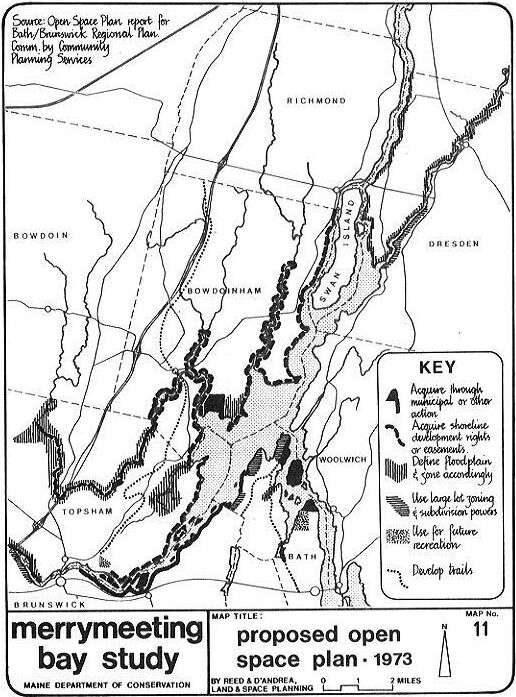
The March 1973 Open Space Plan prepared for the Bath/Brunswick
Regional Planning Commission does not address recreation in terms of
park and playground needs or in terms of needed activities but
focuses on the visual/natural environment. This plan, like SCORP,
recommends the formation of a regional agency to acquire, plan, and
develop land for open space purposes. It also puts some emphasis on
the creation of trail systems in the Bay area.
The most significant recommendations of the Open Space Plan concern
land acquisition. These-are described in this report and shown on
Map 11.
The existence of eight rod & gun clubs in the Bay area attests
to the popularity of fishing and hunting there. The fact that
Merrymeeting Bay produces some of the best smelt fishing and
waterfowl hunting in the state again speaks to the importance of
these recreational .pursuits. Deer hunting is also enjoyed by many
area residents.
Merrymeeting Bay falls primarily into the West Coastal deer hunting
unit (as defined in a 1966 Maine Department of Inland Fisheries and
Game leaflet). The unit as a whole has the largest resident popula-
tion and experiences the lowest hunter kill ratio in the state. The
table below shows the deer harvest for the Bay area towns for the
years 1968 through 1972. In those years, the harvest varied from 227
deer to 574 for seven towns excluding Richmond, Little can be deduced
from these figures; the harvest fluctuates annually depending on a
variety of factors. The kill ratio per hunter, however, is likely to
remain low because of population increases in the area as a
whole.
TABLE: 5-2 Deer Harvest by Town 1968-1972

TOWNSHIP	1968	1969	1970	1971	1972
Dresden		99	69	94	73	88
Bath		6	12	5	3	6
Bowdoin		163	60	62	27	92
Bowdoinham	124	75	81	38	90
Topsham		72	52	51	36	69
Brunswick	38	27	15	11	12
Woolwich	72	80	69	39	89
TOTALS		574	375	377	227	446

SOURCE: Time and Tide, SCS 1974.
Mendall and Spencer in "Waterfowl Harvest Studies in Maine"
(1948-1957) provide considerable information on duck hunting in
Merrymeeting Bay and, although this data is dated, it is evident,
according to Howard Spencer, that the trends noted then are much the
same today.
Bird kills in the Bay averaged 2.53 birds per man-day in the
1948-1957 period and 2.4 in 1971 (the state average is 2.1 per
man-day). Some 20% of the total in-state waterfowl hunting occurs
there. Black ducks compose over 50% of the harvest with Green-winged
teal, Goldeneye, Blue-winged teal, wood duck, and Bufflehead being
the next most hunted birds. Among the factors that make Merrymeeting
Bay such an important waterfowl hunting area are: (1) it combines
both coastal and inland waters; (2) the nature of the vegetation
makes it attractive to migrating waterfowl; (3) early migration
patterns of young ducks to the Bay increase early season
concentration; (4) it is easily acces- sible to a large proportion of
the state's hunting population.
Spencer contends that today's hunters regulate themselves and he does
not foresee a situation where overcrowding could become a problem.
Gary Donovan, Regional Wildlife Biologist for the Department of
Inland Fisheries and Game, states that hunting pressure varies
considerably throughout the fall with the heaviest effort being on
opening day,
In a survey conducted by this office, waterfowl hunters indicated
that they hunted throughout the Bay but concentrate on the vegetated
tidal flats (see Map No. 12).
Public and private access to the Bay is gained mainly at the
following locations: the Bath downtown waterport, West Branch Cove,
Butler Cove, the Old Bath Road told bridge crossing), Centers Point,
Cork Cove, at the bridges at the mouths of the Abagadasset, Eastern,
and Muddy Rivers and in the villages of Richmond and Bowdoinham (see
map). Two new public access points are presently being developed by
the Department of Inland Fisheries and Game, one off Route 24 on the
Muddy River in Topsham, the other on the east bank of the Eastern
River in Dresden, south of the village. There is still a need for
access points on the east of the Bay.
Rod and gun club-owned land is mapped on Map No. 12. Fishing is an
active recreational sport in the Bay and smelt, striped bass, and
perch are commonly caught. Smelt is caught primarily at smelt camps
on the rivers of the Bay (see map). As the table below indicates,
there were 476 camps in the area in 1971. The season depends on the
weather, but most camps are in place in early February and remain
through much of March. The main income from smelt is derived from
rental, bait supply, and wood sales rather than from the value of
smelt caught.
TABLE 5-3 SMELT CAMPS (1971)

Area			Private	Rental	Total
Eastern River		139	129	268
Cathance River		75	45	120
Muddy River		19	0	19
Abagadasset River	62	7	69
TOTALS			295	181	476

SOURCE: The Anadromous Smelt Fishery of Maine, Lewis Flagg, June 1972.
Sturgeon are also taken by local fishermen in the Eastern and
Cathance Rivers.
A questionnaire prepared by this office and addressed to all the rod
and gun clubs utilizing the Bay resulted in only four responses,
despite follow-up phone calls. Much of the information obtained from
these has been incorporated into this report, however, the following
statistics are of interest:
TABLE 5-4 ROD & GUN CLUB MEMBERSHIP & ACTIVITIES

Club Name		No. of		Deer		Waterfowl	Fishermen
			Members		Hunters		Hunters
Bowdoinham Rod &
Gun			40-50		35		all		all
Sagadahoc Rod &
Gun			125		100		70		40
Bath Rod, Gun &
Skeet			+ 50		20-30		20-30		10-20
Wiscasset Rod &
Gun			30		10		10		?
Of interest is that despite the fact that deer kill ratios in the
region are low and waterfowl ratios high hunters in the Bay area
participate in both in equal numbers.
One club felt that "posted land is a problem" and suggested that
hunting rights be obtained from shoreline residents by lease or gift
or outright purchase. The same club was in favor of tight
restrictions on development so as to insure the preservation of the
Bay in a wild state. It was also suggested that the Butler Cove
access be improved for boat launching and parking (the land is owned
by the City of Bath).
Bowdoinham has a like problem in that the town has stopped parking
around the "Abby" bridge; access and parking in this area should be
improved according to the respondents.
Boating on the Bay is primarily related to fishing, waterfowl
hunting, and bird watching. Some canoeing takes place but is confined
mostly to the Eastern, Abagadasset, and Cathance Rivers.
No boats are permitted in the wildlife sanctuary areas of the Bay and
there is a general speed limit of 10 m.p.h. for all areas except
those within the buoyed channels. In some areas the Bay is unsuitable
for recreational motorboating as the tidal changes make the water
depths unpredictable. Portions of the river channel are used,
however, for occasional recreational excursions. This is particularly
true of the Kennebec around Swan Island where a survey at the
Richmond landing in the summer of 1972 indicated that 67% of the boat
trips were for excursions (see table below). Little research,
however, has been conducted as to the number, type, and purpose of
boats using the Bay; although as mentioned above the Bureau of Parks
and Recreation did undertake a statewide boat user survey for the
months of June, July, and August. That survey included monitoring the
Richmond Park public landing for which the following statistics
apply:
Average daily use on weekends		45,6 boats
Average daily use on weekdays		28.3 boats
Percentage of Motorboats		95%
Percentage of Canoes			5%
Percentage of Fishing Excursions	33%
Percentage of Recreational Excursions:	67%
It should be noted that these are figures for a few months for only
one access point; in addition, they are extrapolated from only 20
hours of on-site observation. Further, they do not give any idea as
to boat use during the hunting season. One point is of particular
interest, however, 97% of the persons using the Richmond landing were
Maine people, a high figure considering this survey occurred during
the peak tourist season.
Canoeists use the Eastern, Abagadasset, and Cathance Rivers. The
Eastern is used by summer camp canoeists and some canoe down river to
camp overnight on Swan Island.
The best canoeing on the "Abby" is between the railroad crossing and
the river mouth. The best route on the Cathance is between the old
mill site on the Cathance Road in Topsham and the village of
Bowdoinham (Map No. 4).
The Coast Guard operates a buoy boat for maintenance of the channel
markers and also uses an ice cutter on occasion to break up spring
ice so as to maintain the Kennebec channel. They also provide a
search and rescue service.
During the peak waterfowl and foliage seasons, organized excursion
boats visit the Bay. The Maine Audubon Society organizes some of
these, leaving for trips out of Bath and Southport. In 1975 four such
trips will be scheduled for mid-April and two in the fall.
Some residents feel that there is a need for harbormaster for the Bay
to police the speed limit, channel boundaries, and any boating
restric- tions. Such an individual could also police the smelt camps
in winter.
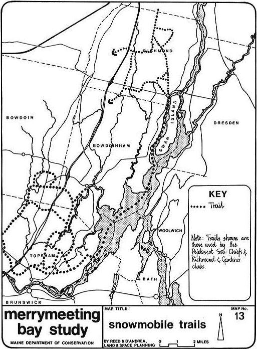
Snowmobiling has enjoyed increasing popularity over the past five
years. Registration statewide has increased from over 29,000
snowmobiles in 1969-70 to over 60,000 in 1973-74. This popularity is
reflected in the number of snowmobile clubs that have formed all over
the state. Six clubs operate in the Merrymeeting Bay area. These
clubs were sent questionnaires by this office; however, the response
was so poor that few conclusions can be drawn. Two clubs sent partial
answers to the questionnaires; these are summarized below.
The Dresden Snow Valley Riders have 70 members and expect membership
to remain at this level, They meet about six times a year, have a
clubhouse in the village and have about 15 miles of marked trails,
most of which lie to the east of the village and the Eastern
River.
The Pejebscot Sno-Chiefs have most of their trails in Topsham.
The map shows their approximate location. It
should be noted that snowmobiles use the Bay itself as a trail area
when it ices up.
The 106th Legislature gave the Bureau of Parks and Recreation the
responsibility of planning for snowmobile trails and "related
facilities," the objective being to determine trails currently in use
and to establish a statewide system of trails. The Bureau, with the
Regional Planning Agencies, has a 75% state--25% local, grant-in-aid
program to assist municipalities in this endeavor. No towns in the
Bay area have applied for funding as yet.
Since snowmobiling is a winter sport the possibility of utilizing
their trails for hiking and riding during the spring, summer, and
fall is worth investigating, especially as the SCORP study identified
a need for such activities. (The SCORP plan did not, however, suggest
land acquisition specifically for snowmobiles.)
A number of other outdoor recreation activities occur in the study
area on a less intensive scale than those mentioned earlier. These
are discussed below.
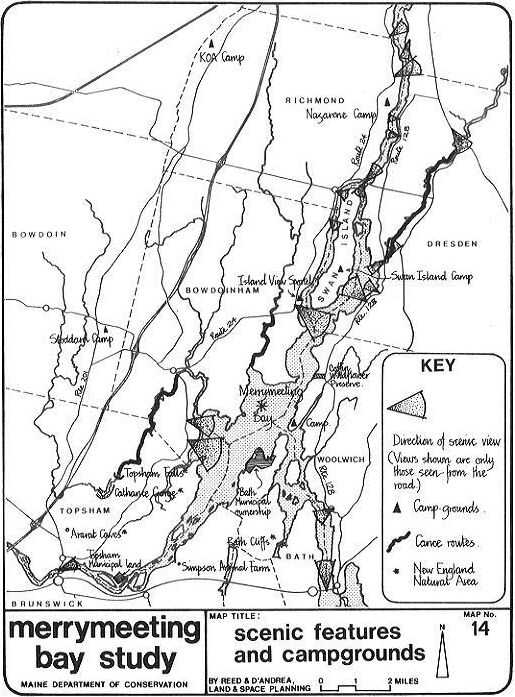
Scenic drives (or sightseeing drives) are popular with tourists and
in-state residents alike; they are particularly important to less
physically mobile persons. Although, as has been stated, the Bay area
roads are not of outstanding scenic value, they are utilized for
sight- seeing. They also provide some scenic vistas of the Bay and
its rivers. For these reasons they should be improved as scenic ways
and steps should be taken to ensure that the few vistas be preserved
and enhanced-- perhaps as scenic picnic areas or simply as turnouts.
The more important scenic viewpoints (from a motorists' or cyclists'
standpoint) are located on Map. No. 14.
Two large summer camps occur in the study area; one in Richmond,
north of the village between Route 24 and the Kennebec and another on
East Chops Point in Woolwich, A private KOA camp is located off Route
201 on the shove of Pleasant Pond in Richmond and Stoddard's Pond
Camps is located eight miles north of Brunswick on Route 201. A
private hunting camp named Island View Sportel is located off Route
24 on the Kennebec in Bowdoinham.
Only one ski facility is located in the area, a small operation
called Sky-Hy on the Meadow Road in Topsham. The vertical descent is
less than 200 feet and on a good day little more than a hundred
skiers use the slopes. There are no opportunities for other ski
slopes in the Bay towns.
Cross-country skiing and snowshoeing are sports fast gaining in
popularity among a segment of the population. Abandoned town roads
and old logging roads (particularly in the upper Cathance valley in
Bowdoin) are well suited to this winter use as well as to snowmobile
use. Again, the dual use of trail facilities such as these should be
investigated with the summer use being riding and hiking.
For persons interested in nature and particularly in bird watching
and wildflowers Swan Island is available for nature trips and the
Inland Fisheries and Game Department has a waterfowl sanctuary south
of Abagadasset Point. The privately owned Robert Tristam Coffin
Wildflower Preserve is located on the east of the Bay above the Chops
in Woolwich. The Department of Inland Fisheries and Game has also
acquired about 160 acres on the Muddy River, an area well suited for
wildlife habitat. Other recent acquisitions by the Department in the
Bay area include an additional eight acres adjoining the Bowdoinham
Wildlife Management Area and seven acres that will give hunter access
to the Bay, in Dresden on the Eastern. All these are mapped on map
No. 12.
As is pointed out in section 3.7 (Significant Natural Areas), Mt.
Ararat Caves, Topsham Falls, and the Cathance Gorge all occur in
close proximity to each other and, together with canoeing and hiking
activities, could become a recreational area. The combination of
scenic, historic, and geologic features found here lend further
validity to conserving the area for recreation purposes (see
map No. 14).
In March 1974 the Bureau of Parks and Recreation and the Department
of Transportation published "Bicycling in Maine." This study notes
that Brunswick has marked bicycle routes for recreation and community
purposes. These are in the village area only. Otherwise no urban or
rural bikeways are recommended in the Merrymeeting Bay study area.
There are no abandoned railroad rights of way either, that could be
adapted for bicycling. At present the only routes would be the
existing rural routes--the least safe of all the bikeway options.
The SCORP report identifies a need for extensive outdoor
recreation space in Region 2. Since the Bay towns are central to the
major popu- lation centers of that region, areas suitable for the
identified activities should be found within them. The foregoing
discussion has, however, shown that some activities preclude others
and that environmental. considerations are important to the location
of particular activities.
Thus, in sum, the Bay itself and its immediate shorelands are best
suited for hunting and fishing and the observation of nature. Various
trail sports, such as hiking, snowmobiling, and horseback riding also
appear appropriate. The Bay is not suited to swimming, extensive
recreational boating, and camping activities.
The roads that skirt the Bay, principally Route 24 on the west and
Routes 127 and 128 on the east, should be upgraded as scenic routes
to cater to the demand for tourist sightseeing and advantage should
be taken of locations that provide scenic viewpoints.
Consideration should be given to the upper Cathance area as a
location for those activities unsuited to the Bay environment yet
needed regionally. Camping sites in this area would be central and
easily accessible from I-95 and Route 201. The wild nature of the
area, the uneven topography, and existence of the Cathance itself
along with a number of old abandoned roads argue strongly in favor of
camping, picnicking, and again trail recreational sports in this
area.
This chapter has also shown that outdoor recreation in the Bay area
towns should be geared to the needs of the local residents and Maine
people--rather than to tourists.
Following is a summation of the more important points made in this
chapter: - Regional outdoor recreation needs (as identified in SCORP)
should be provided for, in part, within the study area (specifically;
trails, camping and picnic areas, and canoeing areas).
- The Bay's best recreational value is for hunting and fishing land
any boating associated with these activities), It is also welt suited
to nature observation, canoeing ton the lower reaches of its rivers)
and boating related to sightseeing (as against power speed boating,
sailing, water skiing, etc.). - Parts of the shore lands are suitable
for trail recreational activities such as snowmobiling, horseback
riding, and hiking. - Routes 24 and 128 could be upgraded for
sightseeing as scenic routes, - Scenic viewpoints, which are
relatively few and far between, should be maintained and developed as
such--possibly as roadside turnouts and/or picnic spots. - The
possibility of using the upper Cathance area in Bowdoin as a state
camping and/or picnic area should be evaluated. The same area should
be considered for the development of trails. - The possibility of
developing the Cathance Gorge area in Topsham for trails, canoeing,
and/or nature study should be considered. - The towns should be
encouraged to establish nature centers and/or the state should
consider establishment of a Merrymeeting Bay nature center. -
Regarding fishing and hunting, the following observations merit
attention: --Better public access to the Bay from the east is needed.
--Some feel that waterfowl hunters will continue to regulate
themselves as far as crowding pressures are concerned. --Some hunters
favor restricting development on the shoreline in order to preserve
the Bay in its wild state. --There is a parking problem for smelt
fishermen at the Abagadasset Bridge. --75% of tourist hunters are
Maine people. --97% of the boat users at Richmond in the- summer are
Maine people. --20% of Maine's waterfowl hunters hunt Merrymeeting
Bay. --Some residents see a need for a harbor master with
jurisdiction over the whole Bay. - Two recent studies (SCORP and the
Open Space Plan) call for the establishment, through legislation, of
a regional recreational (or open space) authority to plan for,
acquire, develop, and manage recreational areas.
The above points when judged in the context of other findings and
viewed in terms of their environmental impact form the basis for the
recommendations contained in Chapter 8.
TABLE 5-5 RECREATIONAL RESOURCES INVENTORY (SOURCE: Coastal Planning Unit, State Planning Office)

BATH Indoor facilities

1. 	Bath YMCA
	2 gymnasiums
	indoor pool
2. 	Bath Marine Museum Outdoor facilities
3.	Merrymeeting Snow-trailers snowmobile area
4.	Butler's Cove
	135-acre, 2-mile frontage for local campers, duck
	hunters; municipal ownership
5.	Bath Golf Club - 60 acres; private
6.	Rod & Gun Club - 27.5 acres; private
7.	Bath Recreation Park; 24 acres including
	4 tennis courts
	1 baseball field
	1 football field
	1 general field
	1 track course
	1 basketball court
	1 swimming pool
8.	Mitchell School
	1 basketball court
9.	Fisher School
	gymnasium
	1 playground
	1 basketball court
	1 general field
10.	Hyde School
	gymnasium
	1 tennis court
	1 football field
	1 track course
	3 basketball courts
11.	Elmhurst School
	playground
12.	Huse-Small School Complex
	2 baseball fields
	1 playground
	2 basketball courts
13.	Dyke School
	1 playground
	1 basketball court
14.	Newell School
	1 general field
	1 playground
	1 basketball court
	1 gymnasium
15.	Morse High
	2 basketball courts
16.	Municipal Waterfront Park
	4 picnic tables; municipal ownership
17.	Goddard's Pond
	skating; municipal ownership
18.	Northend Skating Pond
19.	Library - City Park
20.	Municipal boatdock on Kennebec
21.	Municipal boat ramp - 1 acre; parking for
	50 to be added
22.	Long Reach Mooring
	28 slips, 8 moorings
	boat rental; private ownership
23.	Bath Fuel Marine
	ramp, docking for 20 boats; private
24.	MacDonalds boatyard
	20 moorings, 82 slips; private
25.	Babe Ruth Field - baseball
26.	Swimmer's Rock; private, local. swimming hole.

BOWDOIN

27. 	Adams School
28.	Jacques School

BOWDOINHAM Indoor facilities

29.	Coombs	School		gymnasium Outdoor facilities

30.	Community School
	1 tennis court
	1 baseball field
	1 basketball court
31.	Municipal boat landing; leased to town, ramp
32.	Island View Sportel; hunting camp; private;
	Spear Sedgley, owner

BRUNSWICK Indoor facilities

34. 	Evergreens Drop-in Center (Sr. Citizens)
35. 	Pejepscot Historical Society

Outdoor facilities

36. 	Coffin Pond Nature Park
	cross-country skiing
	16 picnic tables
	skating, swimming beach; public